Barriers to innovation in the Canadian electricity sector and available policy responses
Enabling broader decarbonization through Energy Systems Integration
“Our people have borne witness to climate change through deep time”
This essay was commissioned to inform the research and recommendations in our report Sink or Swim: Transforming Canada’s economy for a global low-carbon future, as part of our Indigenous Perspectives series featuring Indigenous-led initiatives to address and respond to climate change.
In a time of unprecedented crises—including climate change, economic impact, loss of biodiversity, and a global pandemic—we recognize the importance of leadership and collective action to address these crises locally and globally. This essay shares Indigenous insights, concerns, and recommendations to guide the transition to a low-carbon economy. Specifically, it supports establishing Indigenous protected and conserved areas, expanding guardian programs, and building the conservation economy.
Historical and cultural context
Fourteen-thousand-year-old carbon-dated charcoal from a Heiltsuk village campfire located on what is now referred to as Triquet Island in unceded Heiltsuk territory off the Pacific Northwest coast confirms that our people were living on this land many thousands of years before the Roman Empire or the Egyptian pyramids. Our presence was known when the Earth was covered by ice and before the western red cedar migrated up the coast and the salmon populated our rivers, back to a time when sabre-toothed tigers and giant sloths roamed the Pacific Northwest. Our people have borne witness to climate change through deep time. According to this archeological carbon dating, during the first 7,000 years of this vast timescale, our people were harpooning sea mammals, while in the last 7,000 years we were eating more fish, such as salmon and herring.
Our Heiltsuk language also validates this ancient relationship to place. The name of a local marine passage referred to on navigational charts as Nulu Passage originates from the word Nula and in our Heiltsuk language means “eldest sibling.” Nulu Passage is in close proximity to the ancient Heiltsuk village site on Triquet Island. Our language and names also connect us to specific places in our territory and to each other. For example, I have two Heiltsuk names that I received in potlatch ceremonies. The name I carried as a youth, and now share with my grandson, is Athalis, which means “far up in the woods” to commemorate the eight months I spent alone on an island in observance of Heiltsuk ǧvi̓ḷás (laws). It is also the name of a Big House. My Hereditary Chief’s name, λáλíya̓ sila, which means “preparing for the largest potlatch,” was inherited from my late uncle, Robert Hall. λáλíya̓ sila was the first human ancestor who came down at Roscoe Inlet at Clatsja, where he landed on a salmon weir as a half man, half eagle.
Meaningful community engagement is the bedrock of the climate action work currently underway in Heiltsuk homelands. The Heiltsuk have a long history of working together to govern and manage our ecosystem for abundance. For at least 14,000 years, ǧvi̓ḷás (laws) have determined relationships internally, externally, and with the land, waterways, and the spiritual world. Based on principles of respect and balance, this system cultivated abundance through constant change. The last Ice Age and melt were survived by the Heiltsuk because of our strong systems of relationships and values. These same values continue to infuse the work of the Heiltsuk community towards climate action and justice. The latest community engagement of more than three hundred Heiltsuk citizens, held in 2021, demonstrated low conflict and high agreement around transitioning to clean energy. This supportive environment enables the Heiltsuk Climate Action Team to act decisively and coordinate local action on the climate crisis.
Meaningful community engagement is the bedrock of the climate action work currently underway in Heiltsuk homelands.
Heiltsuk Nation’s relationship with nature and the seven fundamental truths
Our Heiltsuk ancestors practised controlled burning of forests, transplanted salmon from salmon-bearing streams to those that did not have salmon, and built clam gardens and fishing weirs to develop a sustainable fishery. This stewardship ethic goes back into deep time when raven transplanted herring from Gildith to Nulu. Throughout our long history of continuous occupation of our territory, our people developed laws and systems of governance that have sustained us through many difficult times. We have been on a journey through time and place that’s depicted in the Heiltsuk’s Sacred Journey initiative, which shares the story of Tribal Canoe Journeys through Indigenous place-based people’s stories, practices, and values—an important example of human resiliency.
In 2009, I served as an Indigenous advisor to Biodiversity BC leading up to the 2010 International Year of Biodiversity. We organized and compiled a report with Heiltsuk, Haida, and ‘Namgis knowledge keepers called Staying the Course, Staying Alive–Coastal First Nations Fundamental Truths: Biodiversity, Stewardship and Sustainability. In this report, we delineated core values, or fundamental truths, that all three coastal native nations subscribe to. These core values are validated through stories, practice, language, and maps. The following seven truths affirm ancient relationships to place and current concepts of biodiversity, stewardship, and sustainability, and provide an important balance for scientific knowledge:
Truth 1: Creation
We, the coastal First Peoples, have been in our respective territories (homelands) since the beginning of time.
Truth 2: Connection to Nature
We are all one. Our lives are interconnected.
Truth 3: Respect
All life has equal value. We acknowledge and respect that all plants and animals have a life force.
Truth 4: Knowledge
Our traditional knowledge of sustainable resource use and management is reflected in our intimate relationship with nature, its predictable seasonal cycles, and indicators of renewal of life and subsistence.
Truth 5: Stewardship
We are stewards of the land and sea from which we live, knowing that our health as a people and our society are intricately tied to the health of the land and waters.
Truth 6: Sharing
We have a responsibility to share and support, to provide strength, and to make others stronger in order for our world to survive.
Truth 7: Adapting to Change
Environmental, demographic, socio-political, and cultural changes have occurred since the Creator placed us in our homelands, and we have continuously adapted to and survived these changes.
The responsibility to care for lands and waters
These fundamental truths have given rise to powerful solutions for addressing climate change and sustaining biodiversity. As Indigenous place-based peoples, we have a sacred responsibility to look after the lands and waters and resources. To achieve our vision of sustainability requires a convergence of local and traditional knowledge, ancestral laws, and the best of what western science has to offer.
For too long, the dominant approach to natural resources has been one of exploitation and exhaustion. But we are connected to the resources that give us life. If we burn through them, we undermine our own futures. Yet if we relate to the natural world in a more thoughtful way, the herring, kelp, salmon, caribou, and moose will remain—not just for us but for generations to come.
To achieve our vision of sustainability requires a convergence of local and traditional knowledge, ancestral laws, and the best of what western science has to offer.
And if we continue relying on carbon-intensive systems, we will not only worsen climate change, but we will endanger the natural systems that sustain us. We have seen the dangerous consequences of these systems firsthand.
On October 13, 2016, for instance, an articulated tug and barge ran aground in Heiltsuk territory. The tug sank and spilled more than 100,000 litres of diesel fuel and 3,700 litres of lube oil, hydraulic oil, gear oil, and spent lubricants into our pristine waters. The vessel operator, who had fallen asleep at the wheel, pleaded guilty, was fined, and funds were set aside to do impact mitigation work. The Heiltsuk currently have a civil suit pending against Canada.
This incident severely impacted our whole community. It was as if a close relative had died. We had to take responsibility for our place through acting as first responders, documenting the first 48 hours, and completing an adjudication report. In the aftermath of the disaster, we plan to establish a Heiltsuk emergency response team and a first responders centre in the central coast of British Columbia. We will also continue expanding the work that maintains healthy lands and waters. This stewardship builds stronger communities and low-carbon prosperity.
Opportunities for Indigenous leadership to improve approaches to development in the Pacific Northwest and boreal region
We have lived in our coastal homeland in relationship with natural resources for millennia. But in recent years, we have seen a sharp decline in ocean resources such as salmon, herring, and Dungeness crabs. Overfishing has taken a toll and so has climate change, creating effects such as big blobs (warm water patches) and higher ocean carbon levels making the water more acidic and altering its chemistry, leading to thinner shells, stunted growth, and premature death in Dungeness crabs.
Heiltsuk Guardian Watchmen track these changes and draw from the expertise of knowledge keepers that has developed over generations. Their research is shaping the Heiltsuk Nation’s decisions about how many crabs can be taken from the water and which areas must be protected to help them recover.
The same pattern is unfolding across the country. There are over 70 Indigenous Guardians programs operating in Canada. Guardians are the eyes and the ears out on the land and the water, and they are helping their Nations respond to climate change. They monitor shifts in the timing of when migratory birds arrive, where caribou find food in winter, when rivers melt in spring, how salmon populations are faring, how drought impacts red cedar, and why wildfires are growing more intense.
Indigenous Guardians are playing a vital role in creating and managing Indigenous Protected and Conserved Areas (IPCAs) across Canada. These areas are critical to Canada’s ability to meet its international climate change and biodiversity commitments, now and in the future.
Indigenous-led conservation is proven to generate sustainable prosperity. Guardians programs offer well-paying jobs that create outsized benefits in small communities—each job supporting family members and purchases in the local economy. IPCAs and Guardians programs also generate new business opportunities and spur investment in regional economies.
Local and traditional knowledge teaches us about long-standing natural systems and processes that have been similar for generations. Climate change disrupts these patterns with erratic shifts in snowpack, ocean chemistry, and timing of seasons.
Indigenous-led conservation is proven to generate sustainable prosperity.
A premise of western research is to establish a baseline. In some cases, western science has between 20 and 80 years worth of data for Northern landscapes. But local Indigenous knowledge is thousands of years old. It is imperative that these two knowledge systems work together to address the climate crisis.
Guardians programs reflect this powerful combination. They join place-based expertise with western tools for measuring water temperature, salinity, permafrost, and other data.
Governments have a role in limiting risks and expanding Indigenous-led opportunities
In many locations, Guardians are the only ones on the land tracking climate change. Crown governments simply don’t have the financial resources to put field stations in remote areas to do this work across the North, but Guardians are already on the ground working in traditional territories. Partnering with Indigenous nations is a fiscally sound approach to helping mitigate climate impacts.
We need the Guardians’ knowledge to inform climate-related policies and decisions, whether it’s setting limits on Dungeness crab harvests or reducing development in carbon-rich lands. Several Indigenous nations, for instance, have proposed creating Indigenous Protected and Conserved Areas in the Boreal Forest. The boreal is the largest remaining intact forest left on the planet, and in Canada alone, it holds about 12 percent of the world’s land-based carbon reserves. Indigenous Protected and Conservated Areas ensure large boreal lands remain undisturbed and prevent enormous amounts of carbon from being released into the atmosphere
Taken together, current proposals would permanently protect well over 20 billion tonnes of carbon—equivalent to almost 100 years of Canada’s annual industrial greenhouse gas emissions.
The work of Guardians benefits not only Indigenous communities, but all of humanity. Guardians draw on thousands of years of relationship with the land to ensure resources that we all depend on—from crab to caribou, clean waters to carbon storehouses—are sustained into the future. As the climate crisis intensifies, it’s time for Canada to support this work. Providing long-term investment in Guardians programs will help Canada honour its climate and conservation commitments and help all of us navigate our changing world.
Opportunities and recommendations
Indigenous communities are inextricable from the environments they are in relationship with, creating a powerful community responsibility to the land, water, and air. It is time Crown governments tapped into the wisdom of this powerful community responsibility through meaningful community-level engagement with Indigenous communities on the climate crisis. The engagement must be solution-focused, community-driven, and well-funded. Indigenous communities must be a driving force behind climate action, not simply have a seat at the table.
It is time Crown governments tapped into this wisdom through meaningful community-level engagement with Indigenous communities on the climate crisis.
The following four areas provide opportunities for collective action:
- Supporting Indigenous-led conservation and stewardship, including Indigenous Guardians. This should be a core part of Canada’s efforts to meet its new commitments to protect 25 per cent of lands and waters by 2025 and 30 per cent by 2030, and should be incorporated in Canada’s post-pandemic economic recovery plan.
- Promoting economic reconciliation, community resilience and prosperity. This includes reimagining what prosperity looks like, addressing economic inequality, and developing new business models that will also help Canada transition to a low-carbon economy.
- Pioneering innovative financing mechanisms and untapped sources to ensure ample resources are available for land and resource management, biodiversity conservation, prosperity, climate resilience, and transition to a low-carbon economy.
- Working with governments to recognize nature-based solutions such as the boreal forest’s ability to capture and store carbon. This includes finding effective ways to create and monetize carbon offsets to provide communities with innovative revenue options for conserving lands and helping Canada meet its biodiversity and climate goals.
Canada is already taking steps towards supporting these efforts, both through the Canada Nature Fund and the National Indigenous Guardians pilot project. These renewed efforts will help us move forward together to create resilient and healthy economies at the local, regional, and national levels, while also helping Canada transition into a low-carbon economy.
Frank Brown is Hereditary Chief and a member of the Heiltsuk Nation from Bella Bella. He is currently an Adjunct Professor at Simon Fraser University, Resource and Environmental Management Department and recently received an Honorary Doctorate of Law from Vancouver Island University.
Indigenous partnerships—the key to meeting Canada’s climate commitments?
This essay was commissioned to inform the research and recommendations in our report Sink or Swim: Transforming Canada’s economy for a global low-carbon future, as part of our Indigenous Perspectives series featuring Indigenous-led initiatives to address and respond to climate change.
I am an Anishnaabe Kwe from Nipissing First Nation, an electrical engineer turned CEO of a business council. I first enrolled in electrical engineering because I wanted to support Indigenous communities to be inclusive participants in the energy sector. While my career has changed in the last few years, my focus is still on enabling inclusive participation of Indigenous communities and businesses, and I still believe wholeheartedly in the opportunity that exists for these communities and businesses in the clean energy transformation that is coming.
Prior to moving to the Canadian Council for Aboriginal Business (CCAB), I managed the First Nations and Métis Relations team at the Independent Electricity System Operator in Ontario from 2014 to 2018. Over those four years, we worked to build requirements to ensure that First Nations and Métis communities in Ontario were active partners in the energy sector. Much of this work happened through renewable procurement. We adjusted policies and program documents to ensure that the procurement of renewable energy was not only accessible to Indigenous communities but also equitable. With each iteration, more communities applied for projects, either as the sole developer or through a partnership. At completion, close to half of the First Nation communities and the Métis Nation of Ontario were partnered on renewable projects through one of those procurements.
The results of our work were very promising, but there was, and still is, a lot more work to be done. There were several communities that wanted to partner or build projects but were not successful due to limited transmission capacity, associates not understanding true partnership or collaboration, or in some cases being constricted by the Indian Act, which limits the control of a First Nation to make decisions about their own land. Had we known all the challenges at the outset, accounted for them in the design, and provided support for communities to be better prepared to respond to procurement opportunities, I am certain that many more communities would by now be generating power for, and revenue from, the grid. Sharing the challenges and feedback from communities can enable community leaders, regulators, proponents, and policy makers in all provinces and territories to accelerate the clean energy transition in ways that support and strengthen Indigenous communities and businesses.
There are still many opportunities for Indigenous partnerships on energy projects and for energy companies to support the growth of the Indigenous economy, both in Ontario and across the country. To be blunt, if proponents, policymakers, and potential partners do not consider Indigenous partnerships or build policies for Indigenous ownership, further development in the clean energy sector will be stalled.
At CCAB, we are seeing the opportunities multiply in this sector. Indigenous communities across the country are building and partnering on projects in the clean energy economy. There are currently over 60,000 Indigenous businesses in Canada, and the Indigenous economy is growing at a significant rate. Over 35 per cent of these businesses are operating in construction, professional, manufacturing, and scientific and technical services—all of which are current participants in the energy sector.
Indigenous communities across the country are building and partnering on projects in the clean energy economy.
Notably, CCAB research indicates that Indigenous Peoples are creating new businesses at nine times the rate of non-Indigenous peoples in Canada, and that Indigenous business owners increasingly recognize the importance of innovation (Canadian Council for Aboriginal Business, 2019). More than six in ten (63 per cent) introduced either new products or services, or new processes, into their business in 2016, up significantly from 49 per cent in 2010 (Canadian Council for Aboriginal Business, 2016). Additionally, there are over 10 energy providers across the country enrolled in CCAB’s Progressive Aboriginal Relations program—demonstrating their commitment to employ, procure, support, and build relationships with Indigenous Peoples.
The interest, the drive, and the businesses are growing, representing an incredible opportunity to meaningfully include Indigenous communities and businesses in Canada’s energy sector and the transition to a clean economy. While several partnerships were built as a result of provincial government policy, we have also seen projects built as a result of corporations righting their past wrongs, such as the Peter Sutherland Generating Station, as well as organizations like NRStor prioritizing building strong relationships with Six Nations of the Grand River on the Oneida Storage project.
Peter Sutherland Generating Station
In March 2017, Ontario Power Generation (OPG) and their partner Coral Rapids Power, a wholly owned subsidiary of Taykwa Tagamou Nation (TTN), completed the Peter Sutherland Sr. Generating Station. The project began with a resolution of the past grievance settlement between TTN and OPG in relation to other OPG hydro projects built in the First Nations’ Traditional Territory. A source of clean, reliable, electricity, the station is located at New Post Creek, about 75 kilometres north of Smooth Rock Falls, within the traditional territory of TTN, who remain 35 per cent equity partners in the station. Named after a respected TTN community elder who passed away in 1998, the station has two units that generate 28 megawatts of renewable, low-cost electricity—enough to power about 28,000 homes. The partnership resulted in more than $50 million in contracts for TTN businesses and about 50 TTN members worked on the project.
Oneida Energy Storage LP
The Oneida Energy Storage Limited Partnership is a joint venture between NRStor Inc. and Six Nations of the Grand River Development Corporation. It is a concrete example of an Indigenous renewable energy partnership with considerable potential to contribute to Canada’s energy evolution. The Six Nations of the Grand River Development Corporation is no stranger to renewable energy and the equal partnership that has been built is a prime example of the benefits of community capacity building. With support from the Canada Infrastructure Bank, Oneida Energy Storage LP and a team of industry leaders are completing a project analysis for what would be the largest energy storage facility in Canada. This project has the potential to provide clean, reliable power capacity by conserving renewable energy during off peak periods and releasing it into the Ontario grid once energy demands reach their peak. In addition, the Oneida Energy Storage LP will create internship opportunities for Six Nations community members and result in training and employment opportunities.
Ontario Renewable Energy Procurement Programs
From 2009 to 2018, Ontario procured renewable energy through two major programs: the Feed-In-Tariff program and the Large Renewable Procurement program.
The Feed-In-Tariff program was introduced in 2009 and went through five iterations. It was a standard-offer program with a set price dependent on the fuel type. Each iteration aimed to keep down the costs to the ratepayer, and to apply feedback and lessons learned from previous procurements while maintaining policy objectives. A priority of the government at the time was to ensure that Indigenous communities were active participants in Ontario’s energy sector. By the last iteration, Feed-In-Tariff 5.0, the following support measures were included to support equal participation of Indigenous communities:
- Security payments, which were required at several points in the process, were set lower for projects controlled by an Indigenous community—to recognize the barriers that communities face to access financing, especially in a highly regulated and high-entrance-cost industry.
- In addition to receiving the standard Feed-In-Tariff price, Indigenous projects received a better price per kilowatt hour proportionate to the amount of equity ownership by the Indigenous community.
- In each procurement, a certain number of megawatts were set aside for projects with greater than 50 per cent Indigenous ownership.
- Priority points were assigned to projects that received a support resolution from the neighbouring Indigenous community or an Indigenous community host.
- An extension was given to the milestone date for operation of projects on First Nation land due to the inability of First Nations to lease land to potential proponents without approval of the federal government.
The Large Renewable Procurement program was introduced in 2013 as a competitive procurement process for projects greater than 500 kilowatts. The program retained many of the similar provisions as the Feed-In-Tariff program. It also included mandatory requirements for proponents to engage with local communities and gave priority to proponents who demonstrated community engagement over and above the mandatory requirements, such as a Band Council Resolution or proof of Indigenous equity participation.
- At the completion of the first round of Large Renewable Procurement, 16 contracts were offered equal to 454 megawatts. Thirteen of those projects had a First Nation partner. Five of them had more than 50 per cent equity participation.
- The successful projects at the completion of the Large Renewable Procurement program saw 15 unique Indigenous communities participating, with two of the projects involving joint partnerships with six remote First Nation communities. The six remote Indigenous communities rely solely on diesel generation and had planned to use the revenue to build clean energy systems in their communities.
As the first Large Renewable Procurement program in Ontario, those are excellent results, but this success was largely due to various iterations and progress made within the Feed-In-Tariff program. An immense amount of progress was due to additional provincial programs that enabled Indigenous communities to build capacity, supporting this growth by covering costs for partnerships and project development. These programs include funding for Indigenous communities to:
- Establish community energy plans through an assessment of options and engagement with their members.
- Support costs in relation to legal and financial requirements to enter into partnerships.
- Support an individual in the community to focus on energy projects and partnerships.
- Support community engagement processes and readiness for future or potential renewable projects.
Unfortunately, with a change in provincial government, a number of those Large Renewable Procurement projects were cancelled. However, there are still opportunities in Ontario and across the country for potential partnerships in transmission, energy storage, and innovative technologies. If I were designing those programs today, I would make three recommendations to any group seeking to foster effective Indigenous partnerships:
1. Build time into the process
It is not enough to incent proponents to partner with communities or vice versa. You need time to build relationships and for communities to discuss the impacts and engage their membership, and it must be built into the process. Meaningful partnerships require trust and relationship building, and we all know that those things take time to develop.
In my own community—which is very well established and has seen considerable economic growth—the decision to use revenues from money held in trust to invest in renewables was made through many community engagement sessions. They were held in person, both off- and on-reserve and online. A decision to move forward was only made once votes were ratified by members. The decision to choose a partner was also made through many in-person community engagement sessions. This was a significant investment of time and money for community staff and elected officials, whose portfolios not only include energy or economic development but most often mental health, education, housing, and elder care as well.
As I said, the Large Renewable Procurement process in Ontario had requirements with respect to engagement with neighbouring communities. Once approved through the request-for-quotes stage, a list of qualified proponents was made public so communities can have some certainty that the proponents are viable partners. However, the feedback received from communities during my time at Independent Electricity System Operator found that although the request-for-proposal process was six to eight months long, many communities reported that they were bombarded with requests to partner in the four-week period before the deadline.
2. Build capacity and ready Indigenous communities for partnership
I heard from many communities that they were not equipped to respond to requests to partner in the timelines the proponents required. While we can continue to assert that proponents must take time to build meaningful relationships, this is extremely difficult to enforce. So how do we better prepare communities for what is coming? We need to ensure early engagement on energy and infrastructure planning and potential projects so that communities are as informed as the potential proponents—or, even better, that they become the proponent.
Indigenous Peoples have been stewards of the environment since time immemorial. The interconnectivity among Indigenous communities, their cultures, and ways of life with the land are reflected in laws and constitute the basis for Indigenous rights as well as responsibilities. Indigenous environmental values, their consideration of the impact on water and treaty rights, and adherence to natural laws are strikingly different than most potential partners. We often say this, but I do not think developers really grasp just how different these concepts are for Indigenous Peoples. For example, what non-Indigenous corporation considers how a project or decision will impact their seventh generation—that is, the impact on descendants that are going to be born in 2215? These impacts take time to consider and evaluate. Decisions are particularly difficult with the introduction of new technologies without historical precedent, such as nuclear waste disposal. If we can resource communities to advance this work, then we are better enabling them to make good decisions for our future when a project becomes a reality.
Additionally, communities have said that they require the necessary support to respond and participate in the conversations necessary to enter into equity projects. Such support might include funding for a full-time energy worker in the community, for legal and financial fees to evaluate financial and ownership models, or for community engagement plans or community governance.
3. Do not be afraid to ask questions
I know sometimes, particularly with Indigenous communities or Indigenous issues, people are worried about saying the wrong thing or asking the wrong question for fear of causing offence, but that has only served to stall conversation, our collective learning, and the country’s progress. Now more than ever, we need to ensure we keep the conversation going
One final consideration: Indigenous people are not one-dimensional. We are not just protestors or just environmentalists; we are artists and engineers and doctors and lawyers. We have been entrepreneurs and business leaders since before Confederation, trading and negotiating, and moving products from nation to nation. We will continue to do so with the needs and well-being of the next seven generations in mind.
Chi Miigwetch
Tabatha Bull is an Anishnaabe Kwe from Nipissing First Nation. As President and CEO of the Canadian Council for Aboriginal Business she is committed to help rebuild and strengthen the path toward reconciliation and a prosperous Indigenous economy to benefit all Canadians. An electrical engineer, Tabatha informs Canada’s energy sector by participating on the boards of Ontario’s electricity system operator IESO, the Positive Energy Advisory Council, the MARS Energy Advisory Council, and the C.D. Howe Institute’s Energy Policy program.
Protecting Biocultural Heritage and Land Rights
Published as part of our Indigenous Perspectives series featuring Indigenous-led initiatives to address and respond to climate change.
1. Introduction and context
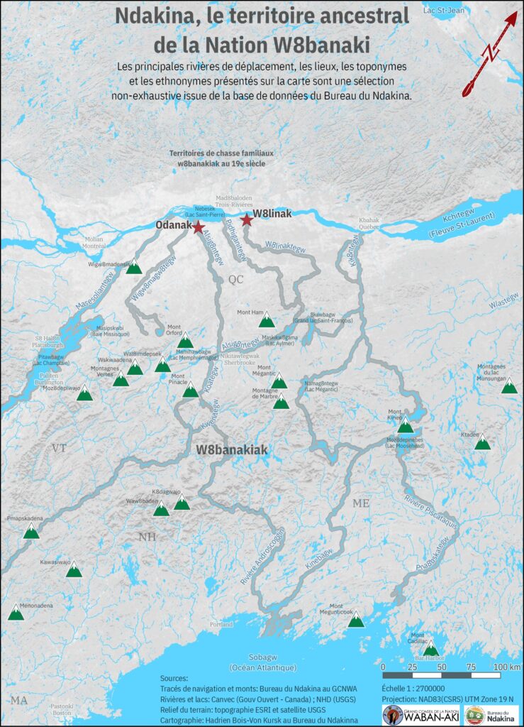
The Ndakina, the ancestral territory of the W8banaki 1 Nation, extends approximately from Akigwitegw (the Etchemin River) in the east to Massessoliantegw (the Richelieu River) in the west, and from the St. Lawrence River in the north to the Atlantic coast and the states of Maine, Vermont, New Hampshire, and part of Massachusetts in the south (see Figure 1). Currently, the Nation has more than 3,000 members in two communities, Odanak and Wôlinak. The Ndakina Office 2 works to safeguard the Ndakina in the long term, mainly via: 1) promoting and defending the Nation’s rights and interests on the Ndakina; 2) representing the Nation in territorial consultations and land claims; 3) documenting, preserving, showcasing and passing on the knowledge of the W8banakiak; and 4) supporting the Nation in fighting and adapting to climate change. To fulfill this mission, the Office favours an approach of territorial affirmation rather than comprehensive land claims.
The right of the W8banakiak to traditional activities, cultural continuity, and self‑determination is connected to territorial integrity. Research on modern use and occupation of the land conducted by the Office and for specific groups in the Nation (for example, youth or women) has clearly demonstrated this (see, for example, GCNWA, 2016). This research has also shown that human activities such as agricultural intensification, land privatization and the pressure exerted by commercial and sport practices have significant impacts on the Nation’s traditional activities (hunting, trapping, fishing, gathering, etc.), knowledge, health, and, ultimately, stewardship capacity. Despite these significant constraints and albeit with difficulty, the W8banakiak have been able to continue their ancestral activities over the years (Gill, 2003; Marchand, 2015).
To these pressures, climate change has now been added. The Grand Conseil de la Nation Waban-Aki launched projects focused on adapting to climate change in 2014–2015, based on an initial plan 3 (GCNWA, 2015).
As part of this initiative, members reported on how climate change is affecting the abundance, distribution, and health of species of wildlife, fish, and plants. One major effect is that, for many, the cycle and timing of hunting, trapping, and fishing have been disturbed; this varies between seasons but has intensified over the years. For example, hunters and trappers must stagger or sometimes cancel their activities. Winter travel has become more dangerous because of the fragility of the ice. Populations of some native species (for example, yellow perch) have dropped, and their meat may be of lower quality due to the proliferation of parasites that higher temperatures can bring. The quality and quantity of certain medicinal plants have also been negatively affected by higher temperatures, as when some medicinal plants dry out, they produce less essential oil. The proliferation of exotic invasive species is also an issue. Another major effect that many have observed is disrupted water flow and accelerated bank erosion, especially for Alsig8tegw (St. François River) and W8linaktegw (Bécancour River).
Overall, these changes have had major impacts on the way of life of many members of the Nation who practice sustenance, ritual, or social activities. The fact that these activities are vulnerable to climate change significantly reduces members’ cultural continuity and ability to transmit knowledge and practices, which ultimately impacts their health.
2. Assessing climate change adaptation initiatives
This case study is focused on two specific aspects of climate change adaptation initiatives: 1) project management, and 2) program governance and funding. What factors help a climate change adaptation project maximize its positive ecological and social impact, and what characteristics mean programs can help communities successfully adapt to a warming cliamte?
We find that the Ndakina Office has prioritized access to the land and cultural continuity through three projects to prevent and mitigate the degradation of biological and cultural resources: 1) Evaluating the reproduction success of lake sturgeon and restoring its habitat (2012–2018), 2) Evaluating the impact of climate change on the availability of medicinal plants and the proliferation of exotic invasive species in a health context (2018–2019), and 3) Evaluating erosion and flood risks on the banks of Alsig8tegw (St. Francis River) and W8linaktegw (Bécancour River)] (better known as the Erosion Project, 2019–present). These three examples were selected because they identified similar vulnerability factors and have taken similar approaches to community engagement.
3. The three cases
3.1. Management of species of cultural importance: lake sturgeon
The W8banaki Nation continues to have an important cultural connection with the lake sturgeon4 (the emblem of the Odanak community) and in particular the populations of the St. Lawrence River and its watersheds. The fish remains part of the Nation’s diet, and is especially prized as a dish for community gatherings. For 10 years now, the Odanak Land and Environment Office5 (known by its French acronym BETO) has conducted in‑depth documentation of the reproduction of the lake sturgeon in the St. Francis River, near the Drummondville hydroelectric dam where there is a spawning ground, with a view to proposing avenues for conservation efforts. The resulting research has shown that poor water flow management by hydroelectric stations has a negative influence on the sturgeon’s reproductive ecology, particularly during periods of migration and spawning (Dufour-Pelletier et al., 2021; see also Clément-Robert et al., 2016). Extreme weather events such as droughts, floods or heavy total precipitation further threaten the reproduction and long‑term survival of lake sturgeon in the area (COSEWIC, 2017).
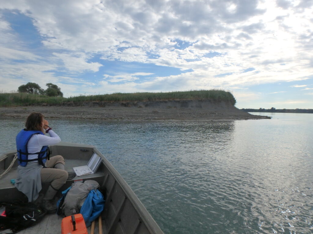
In this context, BETO’s initiatives to monitor lake sturgeon reproduction and recovery have had a significant impact. Site management and water flow management plans have been recently set up, as has a sanctuary area where sport fishing is prohibited before the spawning season. These efforts were made in partnership with major regional actors such as Hydro‑Québec and the Minister of Forests, Wildlife, and Parks. Such protection and management measures are a hopeful sign for the species’ reproductive success and survival rate in the future. On the technical side, the BETO has developed advanced monitoring and management techniques. In a meeting, the project manager strenuously insisted that testimonials from certain W8banakiak fishers and knowledge holders were important for identifying and characterizing research sites of interest for initial work, planning and following up.6 In this sense, the efforts regarding the lake sturgeon are an excellent example of the integration of W8banakiak knowledge with western science. On the socio‑economic side, the long‑term project meant that a good dozen W8banakiak could be hired and trained, deepening the cultural ties between members and this emblematic species (see Photo 1). Furthermore, in material and financial terms, the funds generated helped to consolidate and grow the BETO, increasing its credibility and legitimacy with other regional actors.

3.2. Managing medicinal plants and exotic invasive species
In various studies, members have consistently stated that the intensification of climate change is disrupting the distribution and quality of plant species in southern Quebec. This disruption includes the proliferation of certain invasive species (for example, common reed and Japanese knotweed), which compete with valued species such as cattails or yarrow (GCNWA, 2015, 2016). Climate change also lowers the quality of important indigenous plants, as global warming leads them to dry out more quickly. These problems are of significant concern. At issue is not just a resource, but also members’ capacity to transmit knowledge and educate future generations. This is all the more concerning given that the W8banakiak have suffered the disruption of their ethnobotanical knowledge due to the colonial past and divisions between generations that they experienced; despite these challenges, interest in this knowledge and these practices continues (GCNWA, 2016).7 The project had two objectives regarding these issues: 1) to document and promote the availability and variety of medicinal plants in communities in a time of climate change, and 2) to promote the transmission of knowledge about medicinal plants, traditional medicine, and climate change.
The project promoted intergenerational ties by directly connecting Elders with younger people, which led the younger participants to develop a strong interest in traditional medicine.
The project had several positive outcomes. Interviews with knowledge holders gave researchers a better understanding of their perceptions of climate change’s impact on medicinal plants and ethnobotanical knowledge. A transect inventory method developed by the BETO, the BETW, and knowledge holder Michel Durand Nolett, used especially in wetlands and forested areas, helped provide more in‑depth data on the zones prioritized by the two communities and on plant species of seasonal interest. Vulnerable areas were identified by cross‑referencing the distribution of plant species of interest with that of EIS. The study also had a capacity‑building and awareness‑raising component: knowledge holders led sharing workshops, a community garden was set up, a booklet and videos on medicinal plants were developed, along with other efforts to raise awareness of EIS‑related issues (see Photo 2). The project promoted intergenerational ties by directly connecting Elders with younger people, which led the younger participants to develop a strong interest in traditional medicine. For example, a young Abenaki woman working at the BETO has now been approached about taking over the transmission of such knowledge about ancestral plants.

3.3. Assessing erosion and flood risks in the context of climate change
Water systems have always been dwelling places for the W8banakiak. Alsig8tegw (the St. Francis River) and W8linategw (the Bécancour River) are key witnesses of the Nation’s presence in Quebec, first semi‑permanent and then permanent. Many locations along the banks of these rivers have been recognized as important places of occupation and registered by Quebec’s Minister of Culture and Communications. Oral and written sources and settlement patterns have also identified other sites of great potential interest (for example, portages, campsites, ceremonial sites or burial sites). Today, many W8banakiak still practice activities on the same rivers, including hunting, fishing and gathering. However, climate change is accelerating erosion along Alsig8tegw and W8linategw (Roy and Boyer, 2011; Tremblay, 2012). Members confirmed this trend in interviews conducted for the climate change adaptation plan (GCNWA, 2015). Erosion and sedimentation can have major impacts on water quality and fish habitats, and therefore fishing. They can also damage important archaeological and cultural sites.8 The first phase of the project to assess erosion and flood risks along the banks of the rivers Alsig8tegw and W8linaktegw in the context of climate change established the extent of the degradation and documented its impact on the archaeological and cultural heritage of the region.
From this work, observation and recorded data have tracked erosion mechanisms in dozens of zones with archaeological or cultural potential, the implementation of erosion vulnerability indices, and the creation of tracking sheets (see Photos 3 and 4). This risk assessment should help the Nation to better plan and manage the efforts needed to mitigate erosion impacts and protect these sites. As in the lake sturgeon monitoring project, some W8banakiak recognized for their knowledge of navigation were consulted to help researchers understand the history of, and changes in, the hydromorphology and ecology of the two rivers. Beyond archaeological considerations, one field employee reported that the project allowed them to explore the territory in greater detail than usual, because of the study’s intersections between biophysical features and topological features. This work helped to build the capacity of the archaeology and biology teams and opened the door to developing joint projects. Once again, BETO and BETW participation in this project and its fieldwork activities provided jobs to members of the Nation.
4. Lessons learned and best practices
4.1. Lessons learned for climate change adaptation advance planning
As stated above, the GCNWA launched its climate change and adaptation efforts with the help of a provincial program to support the creation of climate change adaptation plans. Since the funding was short‑term (one year, after a long approval period), the program excluded all implementation activities, preventing any application of a longer‑term and more promising vision.9 Members of the Ndakina office and the BETO and BETW pointed out many other gaps as well, including the limited scope of the consultation and the top‑down plan implementation approach that involved excessively close monitoring of the process and delays in execution. The result of this process was a rigid and standardized plan. It was difficult to integrate members’ key concerns, such as traditional Indigenous knowledge, which was dismissed in favour of measurements and quantification. (For example, little consideration was given to observation of ice or snow.) In retrospect, the focus on exhaustive data collection, analysis, and written reporting was deemed to be distant from members’ more concrete and practical priorities.
In response to this institutional context, and although the climate change adaptation plan provided significant information and orientations that directly led to some climate change adaptation projects, the Ndakina Office, the BETO, and the BETW launched an adaptation program that was more closely aligned with the priorities that members had expressed in various consultations on the use and occupation of the land, working with the opportunities available at the time. This is a more bottom‑up approach to planning.
4.2. Lessons learned for managing climate change adaptation projects
In our experience, when developing projects, it is important to take into account ecological, social and cultural dimensions and the Nation’s interests for the Ndakina. Good starting hypotheses for research work and correct diagnosis also require appropriate mobilization of scientific and traditional knowledge. The participation of knowledge holders and members (particularly Elders and youth) as advisors and for validation is especially useful for achieving this. Greater involvement of the Nation’s members and elected leaders remains a constant challenge. We have observed that they will get involved more directly in projects that provide them with tangible benefits (for example, jobs or salaries, access to equipment, or training or learning opportunities).
On a broader scale, we have seen that strong collaboration between the Nation’s administrative units and regional actors has allowed for a deeper analysis of issues and for more ambitious initiatives. In the two sections that follow, we will see that additional factors, such as the institutional and financial context, may be catalysts or obstacles for projects.
4.3. Lessons learned for climate change adaptation governance and funding
A project’s success depends greatly on the source and nature of its funding. The issue here lies in defining what “high‑quality” funding means for First Nations communities. The experiences of the three projects presented here show that quality funding must be sufficient, stable, flexible, available in cash and in kind, and tailored to community needs.10 Obviously, the volume, stability and long‑term continuity of funding help to ensure greater autonomy in planning and implementing climate change adaptation. For example, wildlife management and inventory work for the lake sturgeon predate the climate change adaptation plan and benefit from substantial multi‑year funding from the Aboriginal Fund for Species at Risk that allows for consistent program‑related decision making. This continuity of funding makes it possible to plan long‑term activities and thus maximize their impact. It is no less important, however, to obtain more ad hoc funding, given that the land and environment offices are small organizations. Such funding allows them to round out work teams, provide competitive wages to members of the Nation, and invest in up‑to‑date equipment.
In all three cases, feedback emphasized the value of funders leaving a certain amount of flexibility to project heads, resulting in greater independence in articulating the project and its orientations. Of the three projects, two were nearly not funded because they did not match the initial scope of the programs. For the project on medicinal plants done in collaboration with Indigenous Services Canada and Health Canada, it was necessary to negotiate the project’s eligibility before funding was obtained, which pushed back the approval and start‑up phases. The Erosion Project ran into similar difficulties. The Department of Crown‑Indigenous Relations and Northern Affairs deemed work with an archaeological component to be ineligible for funding. The application was refused at first, but accepted after discussion and negotiation of the program’s scope.
A certain degree of independence is not the same thing as carte blanche. The Ndakina Office administrators we met with recognized the value of effective follow‑up. They appreciated when funders went beyond their administrative role to provide technical contributions as well. Another aspect of follow‑up they mentioned was the need to distinguish between the importance of ensuring project compliance (for expenses or deadlines, for example) and the importance of providing opportunities to exchange information and learn, especially between project leaders and the funder and between different communities funded (Indigenous and non‑Indigenous). Certain GCNWA‑led projects have a strong potential for being duplicated in or transferred to other communities or contexts, particularly innovative projects and those that were notably successful. Similarly, the Ndakina Office considers that, in current funding programs, the component for the community of practice to learn and share results is a poor relation of sorts, and that platforms showcasing successful Indigenous projects are extremely rare if not non‑existent.
In our experience, available funding must be designed in a specific or targeted manner for Indigenous communities (or, more broadly, for small rural communities). Otherwise, it is difficult for small administrative bodies like the Ndakina Office or the BETO/BETW to submit competitive applications. One possible solution would be to strengthen an association’s connections with regional organizations that have compatible visions and goals (for example, watershed organizations for the Erosion Project), to enable small organizations to seek more substantial funding. Other potential allies include major programs working to protect at‑risk species (such as the Aboriginal Fund for Species at Risk or the Quebec Wildlife Foundation), that set regional priorities each year. However, the species of cultural priority to the Nation (moose, lynx, yellow perch, lake sturgeon, etc.) rarely appear in those lists.11
The Nation’s sovereignty is negatively affected by this exclusion of key species from at-risk status. We believe that each nation must be able to define their own priority species for funding, but current federal mechanisms do not allow for such flexibility. This issue highlights the necessity of understanding the needs and priorities of each community and its organizations, so that proposed projects can be tailored to the local context and desires.
5. Conclusions and recommendations
The integrity of the Ndakina is critical for the W8banakiak to effectively exercise their rights regarding self‑determination and the practice of traditional activities. Over the last few years in particular, members have shared their growing concerns about the impact of climate change on these rights (hunting, trapping, fishing, gathering, etc.). Climate change affects both the quality and the quantity of species of wildlife, fish, and plants. Such resources also have a high cultural value, so the fact that these activities are vulnerable to climate change also reduces the Nation’s ability to transmit its culture between generations. The climate change adaptation‑related planning and three cases presented here have helped to highlight these concerns and impacts. The concrete outcomes of the three projects include deeper BETO and BETW expertise on the socioecology of the Ndakina, connecting traditional Indigenous knowledge and modern science; greater technical and material skills; tangible benefits for members and knowledge holders; closer collaboration among members, administrative units, and a variety of regional partners; and stronger intergenerational ties to strengthen a culture of territorial stewardship in youth.
The factors that contributed to the three projects’ success in planning, funding, and execution have led us to make the following recommendations.
Community-engagement recommendations:
- Encourage research by communities. This allows them to mobilize their members, suggest good diagnostic measures, and set up efforts that are relevant to the community’s situation.
- Promote participatory approaches to interventions that include Indigenous knowledge and modern science, and consider socio‑economic benefits (wages, building technical capacities) as central elements of participation and inclusion.
- Encourage opportunities for networking in a spirit of collaboration between First Nations and regional actors whose missions and activities are often complementary with regard to sustainable environmental management.
Planning and funding recommendations:
- For climate change adaptation plans (an essential tool for conceptualizing the issues, objectives, efforts and key stakeholders to involve), consult with members widely and in an ongoing way, and ensure that the planning framework comes from the community rather than following a template.
- Provide Indigenous communities with recurring core funding so that they can both fight, and adapt to, climate change.
- Ensure that funding for climate change adaptation programs is more flexible and able to accommodate cultural, spiritual and other dimensions, to fit the more holistic First Nations understanding of the land.
- Adapt funding in certain sub‑sectors (such as species conservation) to communities’ specific needs and priorities.
- Ensure that funding options open the door to more technical support and to opportunities for learning and discussion among participating First Nations.
The W8banaki Nation is currently updating its previous climate change adaptation plan, which covered 2015–2020. We have learned a great deal from the adaptation projects carried out in the last few years, and have every hope that this plan will take a queue from more inclusive planning processes so that we can work to successfully ensure the long‑term integrity of the territory needed for the Nation’s cultural continuity and self‑determination.
About the authors
Rémy Chhem is Environmental Project Manager at the Ndakina Office and is currently completing a Ph.D. in international development at the University of Ottawa.
A member of the W8banaki Nation, Suzie O’Bomsawin has worked as Director of the Ndakina Office of the Grand Council of the Waban-Aki Nation since 2013. A resident of the Odanak community, she is also very involved in various organizations dedicated to the interests of First Nations.
Jean-François Provencher is Executive Assistant at the Ndakina Office, and holds a master’s degree in environmental management from the Université de Sherbrooke.
Samuel Dufour‑Pelletier is a biologist and Director of the Bureau environnement et terre d’Odanak.
References
Ndakina Office. (2020). Projet de recherche sur l’impact des changements climatiques sur la disponibilité des plantes médicinales et la prolifération d’espèces exotiques envahissantes pour les communautés d’Odanak et de Wôlinak dans un contexte de santé. Wôlinak: Grand Conseil de la Nation Waban-Aki.
Clément-Robert, G., S. Gingras, M. Pellerin and R. Poirier. (2016). Enquête sur les sources de variation de débits de la rivière Saint-François durant la période de fraie de l’esturgeon jaune. Sherbrooke: Université de Sherbrooke.
Committee on the Status of Endangered Wildlife in Canada (COSEWIC). (2017[2006]). Assessment and Update Status Report on the Lake Sturgeon (Acipenser fulvescens) in Canada. Ottawa: Committee on the Status of Endangered Wildlife in Canada, 124 p.
Dufour-Pelletier, Samuel, Émilie Paquin, Philippe Brodeur and Michel La Haye. (2021). “Reproduction de l’esturgeon jaune dans la rivière Saint-François : un exemple de participation des peuples autochtones à la conservation d’une espèce emblématique.” Le naturaliste canadien.
Dumont, P., Y. Mailhot and N. Vachon. (2013). Révision du plan de gestion de la pêche commerciale de l’esturgeon jaune dans le fleuve Saint-Laurent. Québec: Ministère des Ressources naturelles du Québec, 127 p.
Gill, Lucie. (2003). “La nation abénaquise et la question territoriale.” Recherches amérindiennes au Québec, 33(2), p. 71–74.
Grand Conseil de la Nation Waban-Aki. (2015). Plan d’adaptation aux changements climatiques – 2015. Odanak: Grand Conseil de la Nation Waban-Aki.
Grand Conseil de la Nation Waban-Aki. (2016). Étude de l’utilisation et de l’occupation du territoire de la Nation W8banaki, le Ndakina, et des connaissances écologiques traditionnelles qui lui sont associées dans la zone d’influence du projet d’oléoduc Énergie-Est de Transcanada. Odanak: Grand Conseil de la Nation Waban-Aki.
Grand Conseil de la Nation Waban-Aki. (2021). Évaluation des risques d’érosion et d’inondation sur les berges des rivières Alsig8ntekw (Saint-François) et W8linatekw (Bécancour) dans un contexte de changements climatiques. Odanak: Grand Conseil de la Nation Waban-Aki.
Marchand, Mario. (2015). Le Ndakinna de la nation W8banaki au Québec : document synthèse relatif aux limites territoriales. Wôlinak: Ndakina Office, Grand Conseil de la Nation Waban-Aki.
Nolett Durand, Michel. (2008). Plantes du soleil levant Waban Aki : recettes ancestrales de plantes médicinales. Odanak.
Roy, A., and C. Boyer. (2011). Impact des changements climatiques sur les tributaires du Saint-Laurent. Presentation at the Colloque en agroclimatologie of the Quebec Reference Centre for Agriculture and Agri‑food (CRAAQ), Université de Montréal.
Tremblay, M. (2012). Caractérisation de la dynamique des berges de deux tributaires contrastés du Saint-Laurent : le cas des rivières Batiscan et Saint-François. Master’s thesis in geography, Université de Montréal.
Treyvaud, Geneviève, Suzie O’Bomsawin and David Bernard. (2018). “L’expertise archéologique au sein des processus de gestion et d’affirmation territoriale du Grand Conseil de la Nation Waban-Aki.” Recherches amérindiennes au Québec, 48(3), p. 81–90.
Flood Vulnerability and Climate Change
1. Introduction
In a warming climate, Canadian cities are at risk of increasingly severe and frequent floods. Nearly 80 per cent of Canadian cities are built on floodplains, exposing populations, property, and infrastructure to flood risk (Golnaraghi et al., 2020; Jakob et al., 2015). The socioeconomic impacts of urban flooding are expected to worsen in the future because of population growth, expanding developments in flood-prone areas, and more frequent and severe extreme weather linked to climate change (Burn et al., 2016; Honegger & Oehy, 2016; Zhang et al., 2019).
Urban flood risk is the product of three interacting variables: the flood hazard, the exposure of people and assets, and the vulnerability of people and assets to flood impacts (Agrawal et al., 2014; Armenakis et al., 2017; L. Chakraborty, 2021). Most Canadian studies measure the extent and severity of flood hazards, along with the associated exposure of people, property, and infrastructure, but they often fail to include socioeconomic vulnerability. In the context of flooding, socioeconomic vulnerability refers to characteristics of a person or group that influence their capacity to prepare for, respond to, and recover from a flood hazard event (Cutter, 1996; Cutter et al., 2003; Wisner et al., 2004).
Studies from other countries indicate that socially vulnerable communities are disproportionately exposed to flooding and are more significantly affected by its impacts, but there has been little such analysis in Canada (J. Chakraborty et al., 2019; Collins et al., 2019). Spatial assessment of socioeconomic vulnerability is fundamental for identifying local flood risks (Cutter et al., 2013; Guillard-Goncąlves et al., 2015) and would build on existing data about flood hazards to assess the extent to which property and populations are exposed. Measuring the distribution of socioeconomic vulnerability in a community is critical for prioritizing scarce resources to protect those most at risk.
Methods for measuring socioeconomic vulnerability to flood risk in Canada are in their infancy. For this reason, a case study such as this one, which seeks to validate methods, identify data gaps, and draw out potential implications for public policy, can help to advance our understanding. Windsor, Ontario, was identified as a suitable focus due to its considerable exposure to flood risk. The results reveal hotspots of flood risk across neighbourhoods that have both a high concentration of socially vulnerable groups and a high exposure to flooding. We also consider potential policy interventions to address this geographically concentrated flood risk, with a focus on socioeconomic vulnerability.
Study objectives
- Understand the validity of data on socioeconomic vulnerability for measuring flood risk;
- Generate knowledge about the spatial extent and geographic distribution of flood risk across a large urban centre, and assess whether vulnerable communities are disproportionately exposed to flooding; and,
- Consider policy recommendations to address urban flood risk in ways that particularly protect the most vulnerable.
2. Methodology
This case study includes geospatial and quantitative analysis using national maps and datasets of flood hazards, residential properties, and census information (Table 1). The study area is the Census Metropolitan Area (CMA) of Windsor, Ontario, Canada, and the unit of analysis is at the census tract level.12 Flood hazard extents were generated using JBA Risk Management’s 2018 Canada Flood Map, which quantifies fluvial (river-related) and pluvial (rain-related) flood risks at a 30-metre horizontal resolution.13 The 100-year recurrence interval—a flood the magnitude of which has a one per cent chance of occurring in any given year—was used as the hazard scenario (Holmes & Dinicola, 2010).
The number of residential properties in the flood hazard area was determined through GIS-based spatial analysis of a 2018 national dataset of address points generated by DMTI Spatial Inc. The socioeconomic vulnerability of exposed populations at these address points was calculated using Statistics Canada census data for socioeconomic, racial/ethnic, and demographic variables. These data were organized using principal component analysis14 to construct a neighbourhood deprivation index that displayed variation in socioeconomic vulnerability across the community. The maps of residential flood exposure and socioeconomic vulnerability were combined to reveal the geographic concentration of flood risk across the CMA. Finally, a bivariate correlation analysis was performed to investigate whether socially vulnerable groups were significantly exposed to flood risk.
Table 1. Datasets
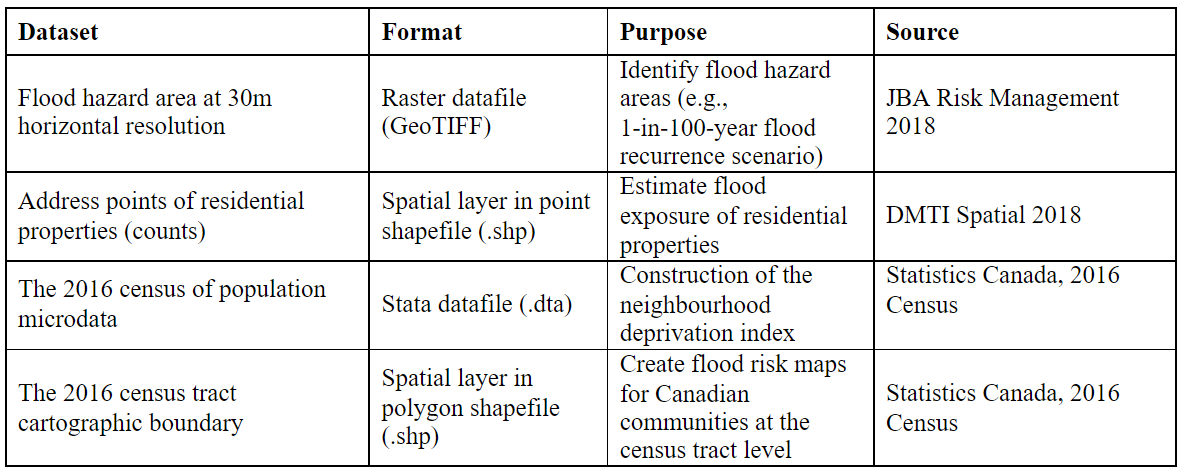
2.1 Study area
The population of the Windsor CMA includes the City of Windsor and the Towns of Amherstburg, LaSalle, Lakeshore, and Tecumseh. Between 2011 and 2016, the CMA population grew by 3.1 per cent, from 319,246 to 329,144. Windsor CMA is the 16th largest metropolitan area in Canada, larger than Saskatoon, Regina, Sherbrooke, St. John’s, and Barrie, but smaller than Victoria, Oshawa, Halifax, St. Catharines-Niagara, and London (City of Windsor, 2018, 2021). Windsor’s socio-demographic profile, key aspects of which are summarized in Table 2, is reasonably typical for a city of its size in Canada.
Table 2. Key Socio-Demographic Characteristics – Windsor CMA 15
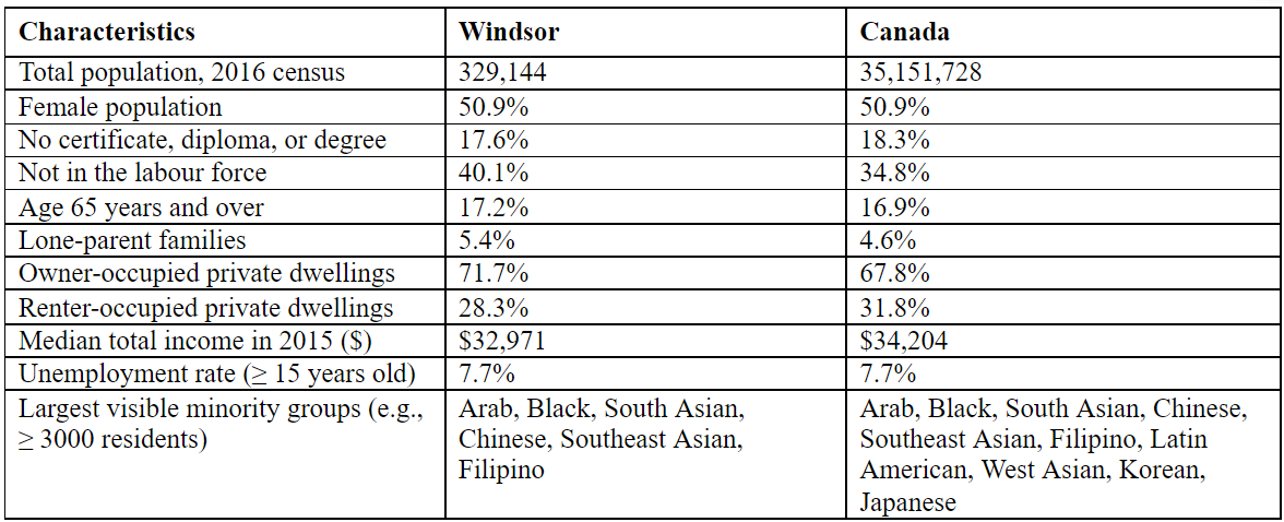
Windsor is located in a low-lying area surrounded by Lake St. Clair and the Detroit River. Flooding has been a consistent problem for the city, with significant events in 2016, 2017, and 2020 (Battagello, 2020; Canadian Underwriter, 2017; CBC News, 2017). An extreme rain event in 2017, for instance, led to flooding in over 6,000 basements and caused $165 million in insured losses (Insurance Bureau of Canada, 2019). In response, the City of Windsor initiated a Sewer and Coastal Flood Protection Master Plan designed to assess and improve its flood mitigation strategies (CBC News, 2020). Given its exposure to flood risk and recent efforts to improve flood mitigation, Windsor is an ideal case for studying the value and implications of socioeconomic vulnerability analysis.
3. Findings and discussion
3.1 Flood exposure of residential properties
Established methods were used to determine flood exposure in three phases (Qiang, 2019). First, the number of residential properties was calculated for each dissemination block.16 Dissemination blocks were used for the property count because they are the smallest geographic units and they cover the entire Canadian territory, which comprises 489,676 dissemination blocks that have unique identifiers and attributes (Statistics Canada, 2018). Second, the total number of dissemination-block-level residential properties was aggregated to find the totals at the census tract level. Finally, the percentage of residential properties exposed to flood hazards in each census tract was calculated using the following equation:

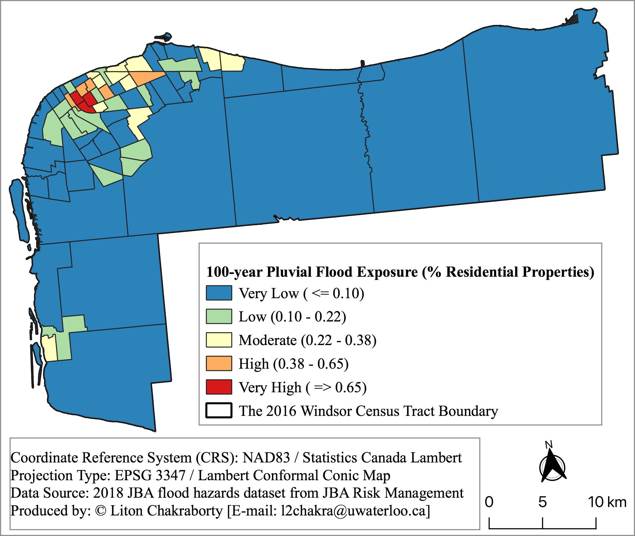
JBA’s flood hazard datasets were imported into ArcMap 10.7.1 to visualize flood-prone areas identified in the Canada Flood Map (Figure 1). Address points were layered onto the flood hazard map using DMTI’s residential address database (DMTI Spatial Inc., 2018).17
Figure 1. Fluvial and Pluvial Flood Hazard Exposure in Windsor CMA
| (a) Residential properties without flooding | (b) Flood hazard exposure |
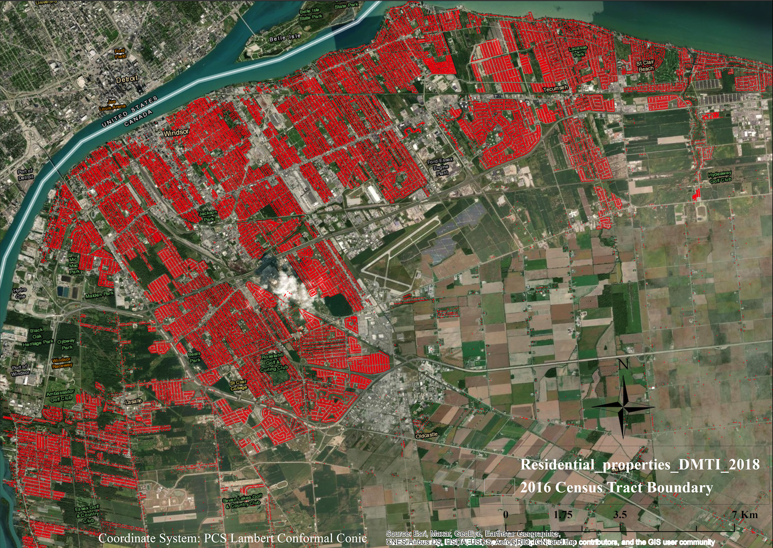 | 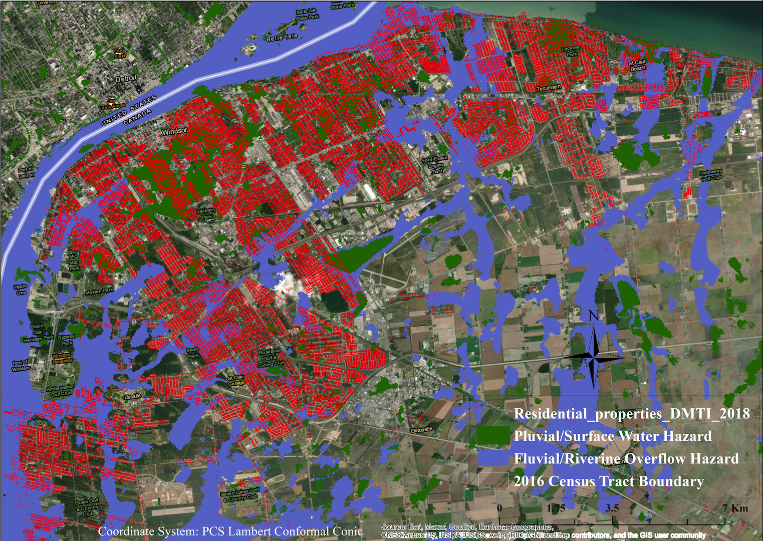 |
Using the plotted outlines of residential properties, a binary analysis (1=yes; 2=no) was used to indicate whether a property intersected with the flood hazard area. The Windsor CMA contains 73 census tracts. There are 118,038 residential properties spread across these tracts, with at least 74 residential properties in each. The GIS-based exposure analysis results were summarized in a spreadsheet and then joined spatially with the census-tract-level cartographic boundary. This analysis revealed 26,722 residential properties (22.6 per cent) exposed to fluvial flood hazard and 19,582 residential properties (16.6 per cent) exposed to pluvial flood hazard.
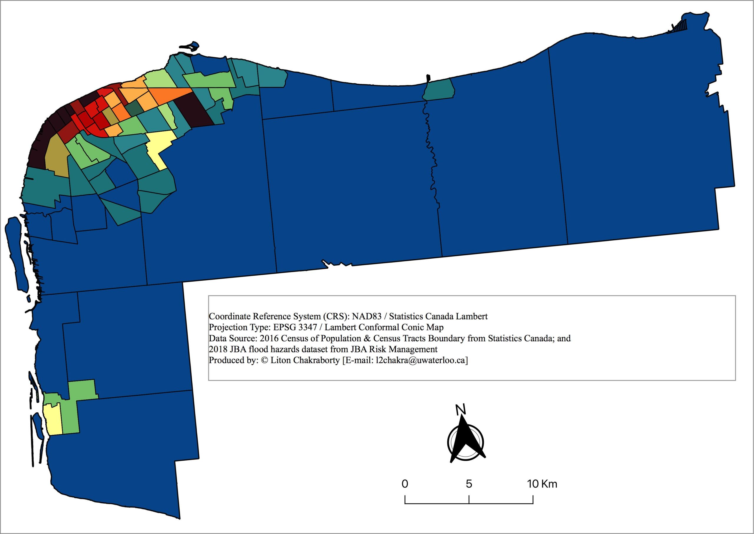
3.2 Socioeconomic vulnerability index
The socioeconomic vulnerability index was developed by compiling relevant indicators that measure a neighbourhood’s social deprivation relative to others. Deprivation indices are designed to capture the socioeconomic status of residents at a neighbourhood level (Bell & Hayes, 2012; Chan et al., 2015). Two deprivation indices—neighbourhood instability and economic insecurity—were most relevant for this objective.
The neighbourhood instability index defines levels of social deprivation by measuring the proportion of the population that would most struggle to recover from unexpected shocks or disruptions. Key indicators for this index include a lack of home ownership, insufficient income, high shelter costs relative to income, lack of a private vehicle, and precarious work or unemployment. By comparison, the economic insecurity index defines levels of social deprivation by measuring the distribution of the population that suffers from insufficient economic resources to sustain a median level of social welfare. People are considered economically insecure if they live in a dwelling requiring significant repair, inhabit a property valued lower than the Canadian median, lack a high school education, require social assistance, or suffer from a physical disability.
These indices provide an additional benefit for socioeconomic vulnerability analysis because they can be linked with demographic census data. Evaluating this relationship can determine whether historically marginalized or disadvantaged populations live in neighbourhoods with high levels of deprivation, in addition to hazard exposure. Descriptive statistics of variables used in the case study are reported in Table A.1 (Appendix A). Methods used to construct the neighbourhood deprivation index and ensure its validity and reliability are described in Appendix B.
3.3 Hot spot analysis: The intersection of flood exposure and socioeconomic vulnerability
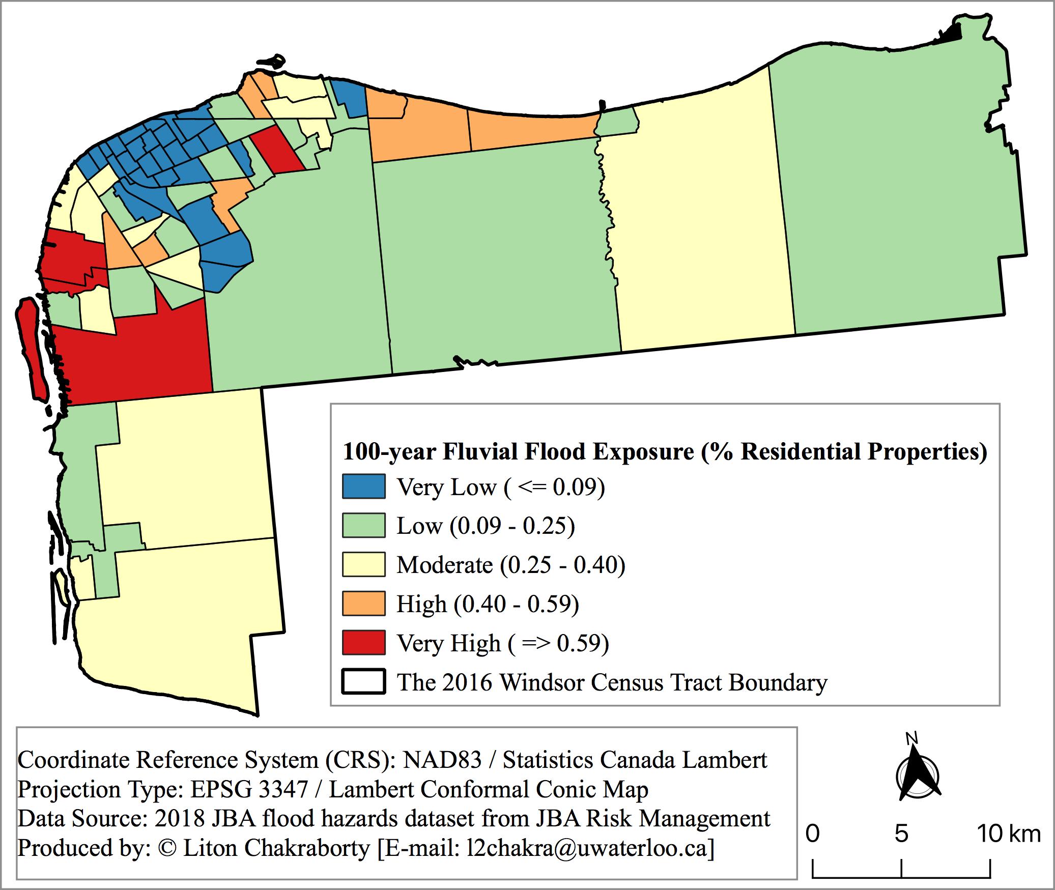
To identify areas at high risk of fluvial flooding, census tracts were classified and mapped into five categories and corresponding colour codes, including very low, low, moderate, high, and very high, based on the percentage of properties exposed to flood hazards (Figure 2a) and their socioeconomic vulnerability scores (Figure 2b). When these maps were combined, census tracts with both high or very high flood exposure and high or very high socioeconomic vulnerability were identified as hot spots of flood risk (colour-coded orange and red) (Figure 2c). The same process was repeated for pluvial flooding (Figures 3a, 3b, 3c).
Figure 2. Flood Risk Assessment for Windsor CMA (Fluvial)
| (a) Flood hazard exposure | (b) Socioeconomic vulnerability |
 |  |
(c) Fluvial flood risk | |
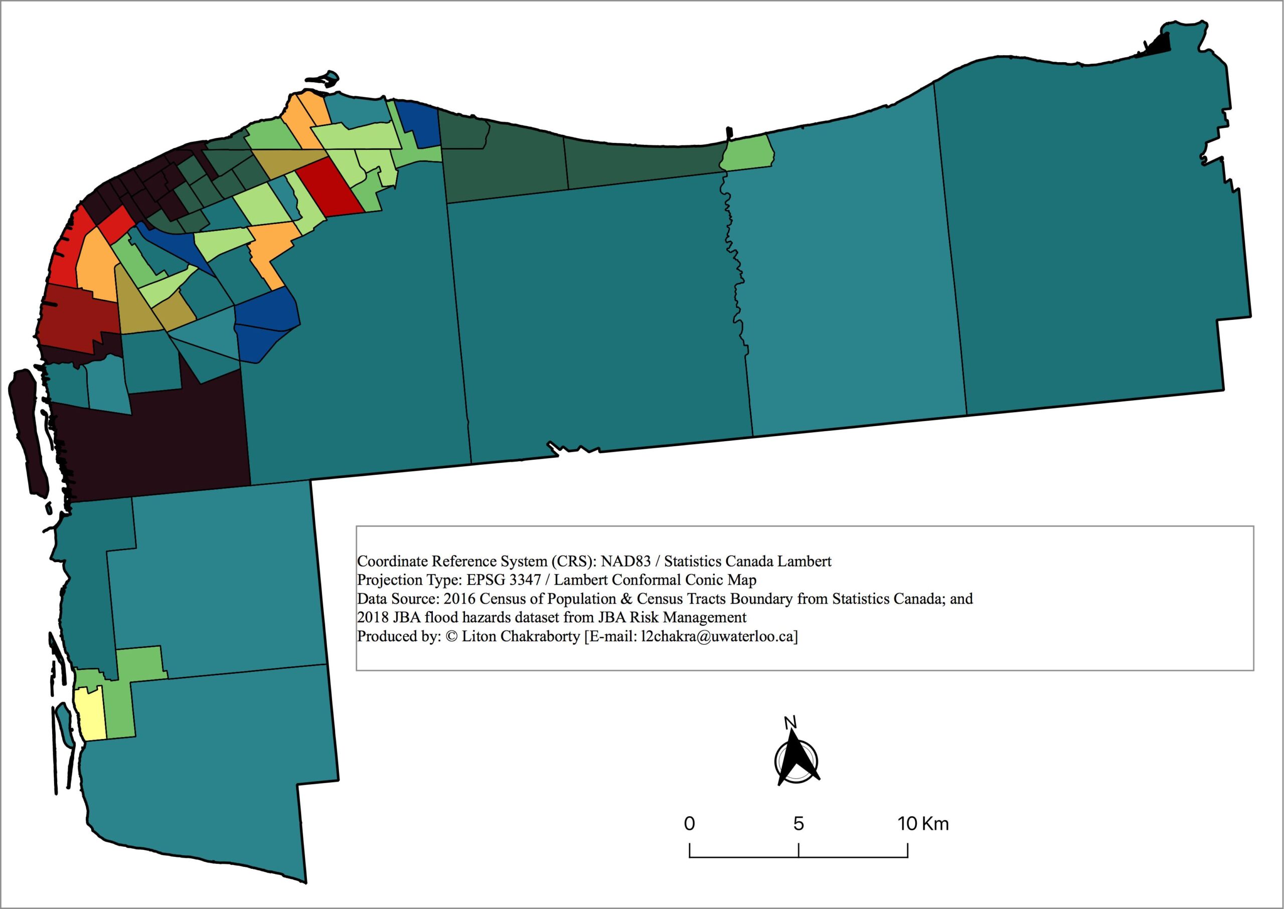 | 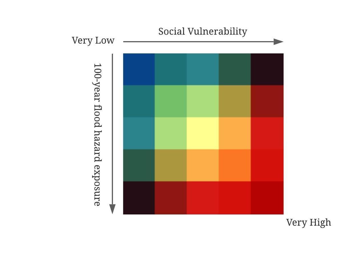 |
Figure 3. Flood Risk Assessment for Windsor CMA (Pluvial)
| (a) Flood hazard exposure | (b) Socioeconomic vulnerability |
 | |
(c) Pluvial flood risk | |
 | |
These maps indicate that both flood hazard exposure of residential properties and socioeconomic vulnerability vary significantly across census tracts in Windsor CMA. Flood risk is concentrated in census tracts where residential properties and populations occupy inland flood zones (mainly the northeast corner of the City of Windsor). Riverine (fluvial) risk intersects with socioeconomic vulnerability in census tracts along the Detroit River, whereas surface water (pluvial) risk intersects with socioeconomic vulnerability primarily in dense downtown neighbourhoods.
3.4 Correlation analysis to inform flood-related inequities
To better understand flood-related environmental inequities, an analysis was conducted to determine correlations between flood exposure and several demographic variables that past research has associated with populations who experience social inequity and injustice. These variables are summarized in Table A.1 (Appendix A).
Based on census data, visible minority populations were grouped as ‘South Asian’, which included people of Chinese, Filipino, Japanese, Korean, and Southeast Asian origin, or ‘Other’, which included people of Arabian, Latin American, and West Asian origin. The Indigenous population subgroup consisted of Aboriginal peoples and people with first ethnic origin identified as First Nations, Inuit, or Métis. Consistent with other Canadian environmental justice and equity analyses (Bocquier et al., 2013; Carrier et al., 2016b, 2016a; Dale et al., 2015), four other socio-demographic characteristics of the population were used in addition to race/ethnicity and neighbourhood deprivation indices. These included (1) per cent female; (2) per cent population aged 65 and over; (3) per cent population aged 15 and under; and (4) per cent population living alone.
Bivariate correlation coefficients are useful to evaluate whether certain populations that are historically marginalized also face disproportionate flood risk relative to other groups (J. Chakraborty et al., 2019; Grineski et al., 2015). This study used Pearson’s correlation coefficients to test the hypothesis that socioeconomically deprived groups disproportionately inhabit inland flood hazard areas, such as fluvial and pluvial flood zones of Windsor (Table 3).
Table 3. Bivariate Correlation Coefficients and Statistical Significance
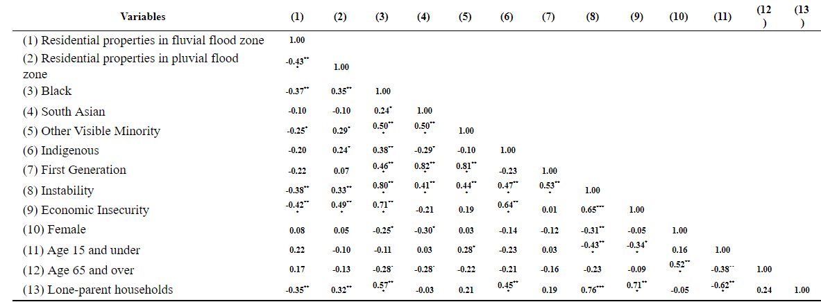
The correlation analysis revealed some statistically significant findings. As indicated by the correlation coefficient of 0.35** in column (2), for instance, Black households are more exposed to surface water (pluvial) flood risk than other population subgroups considered in this study. Indigenous peoples, other visible minorities, and lone-parent households are also highly exposed to pluvial flooding. In addition, pluvial flood risk is more significant in areas with higher neighbourhood instability and economic insecurity.
However, the same correlations were not found for riverine (fluvial) risk, as most of the coefficients in column (1) indicated either negative or statistically insignificant relationships between flood exposure and racial/ethnic and socioeconomic characteristics. For example, the coefficient of -0.37** in column (1) suggests Black households are at lower risk of fluvial flooding. Similarly, the coefficient of -0.20 for Indigenous populations in column (1) indicates that fluvial flood risk for Indigenous residents does not differ significantly from other population subgroups. These results possibly indicate that there are no significant racial and social disparities in exposure to riverine flooding in Windsor CMA. In other words, marginalized and racialized populations in Windsor are likely more exposed to pluvial flood risk compared to fluvial risk.
4. Policy implications for flood risk management
Incorporating measures of socioeconomic vulnerability into flood risk assessment offers several benefits. First, it provides a more comprehensive and robust picture of flood risk. In the case of Windsor, Ontario, the addition of socioeconomic vulnerability revealed that fluvial flood risk is concentrated in areas outside of those captured in more traditional methods that are limited to hazard exposure and physical vulnerability. The pluvial socioeconomic vulnerability analysis revealed that the distribution of risk is more complex and nuanced than what is captured by exposure assessment alone. Subsequent analysis on the distribution of risk across marginalized and racialized populations revealed the potential environmental injustice associated with flood risk in the Windsor CMA. Replicating this type of analysis in other municipalities could reveal different but equally important conclusions about how socioeconomic vulnerability intersects with flooding.
Better risk assessments can focus government policies on people and communities that would benefit most from flood risk reduction. For instance, riverine (fluvial) flood risk is the primary focus of federal and provincial programs, but surface water (pluvial) flooding is a rapidly growing source of risk as increasingly heavy rainfall in a warming climate overwhelms drainage infrastructure and water flows into streets and nearby structures (Gaur et al., 2019). As this analysis shows, even if people live far away from rivers, certain marginalized and racialized groups may experience high flood risk due to their exposure to surface water flooding and higher socioeconomic vulnerability.
The findings also suggest some implications for flood risk management policy. Flood risk communication and education, for example, aim to inform residents about flood risk and encourage household preparedness. Given the correlation between flood risk and marginalized and racialized communities, this analysis suggests that these communication and education campaigns should be tailored and targeted to reach the most vulnerable (Ziolecki & Thistlethwaite, 2019).
The risk assessment and mapping also offer a means to better calibrate non-flood related social programs and policies targeting these communities. As noted above, urban flood risk is the product of interaction between a flood hazard, the exposure of people and assets, and the vulnerability of people and assets to flood impacts. Whereas physical infrastructure can reduce the damage from flood events and purposeful planning can reduce exposure of people and assets, flood risk can also be reduced through social programs that target the determinants of socioeconomic vulnerability, such as low income, unemployment, and high shelter costs (Joakim & Doberstein, 2013; McEntire, 2012). For example, targeted funding made available through disaster assistance programs, subsidies, or vouchers could improve the affordability of flood insurance, which would improve the resilience of communities to recurring flood events, while reducing overall socioeconomic vulnerability.
5. Conclusion
This case study examined the feasibility of combining geospatial and statistical methods for understanding and assessing socioeconomic vulnerability to flood hazards. Based on its high exposure to varying flood risks, the CMA of Windsor, Ontario, was chosen as a worthwhile place to incorporate socioeconomic vulnerability into flood risk assessment. The method employed multiple datasets and statistical methods to triangulate how flood risk changes in response to socioeconomic vulnerability. The findings confirm that there are significant benefits to expanding Canada’s historical approach to risk assessment beyond hazard, exposure, and physical vulnerability to include socioeconomic vulnerability. In the case of Windsor, the incorporation of socioeconomic vulnerability shifted the scale and location of both pluvial and fluvial flood risk.
These findings suggest that policymakers should incorporate socioeconomic vulnerability into flood risk assessments. Indeed, existing approaches limit the benefits of flood risk management by directing resources to areas exposed to hazards but that may have lower levels of socioeconomic vulnerability, rather than areas with higher levels of socioeconomic vulnerability (L. Chakraborty, 2021). In the case of Windsor CMA, for example, some marginalized and racialized communities are highly exposed to pluvial flooding. Understanding the systemic forces that produced this outcome is important, as is the need to target flood mitigation and recovery resources to communities for whom this investment would reduce vulnerability and generate more benefits for the local economy.
It is important to note that the study revealed some areas of uncertainty that could be addressed to improve flood risk assessment using socioeconomic vulnerability. This study used top-down statistical aggregation and modelling that requires a process of “ground-truthing” to ensure its assumptions are valid based on local flood risk conditions. For example, Windsor has data on several recent floods that could be used to validate the flood model spatial outputs. Higher resolution digital elevation data and more refined hydrologic and hydraulic models could also improve the flood hazard layers to achieve more granular analysis than 30 metres.
In addition, the flood data does not include local flood defences such as berms and small dikes to contain fluvial hazards, so including this infrastructure could produce a different result concerning the distribution of flood extent and severity in the area. Rigorous exposure analysis is also needed to reduce uncertainty by including other important assets, such as roads, emergency and health infrastructure, and culturally significant sites. Lastly, because flood risks will continue to grow and change in a warming and increasingly volatile climate, the flood hazard and exposure data should be adjusted to incorporate climate change projections and ongoing land development, including exploring how different emissions and development scenarios influence risk over the coming decades.
Despite these limitations, this case study demonstrates the feasibility of using socioeconomic vulnerability to improve flood risk assessment and management. A key benefit could be improving the cost-effectiveness and equity of mitigation and recovery policies by ensuring resources are allocated to areas that need them most.
6. References (click to expand)
Agrawal, N., Armenakis, C., & Montpetit, M. (2014). Is flooding in Toronto a concern? Natural Hazards, 72(2), 1259–1264. https://doi.org/10.1007/s11069-014-1054-2
Armenakis, C., Du, E. X., Natesan, S., Persad, R. A., & Zhang, Y. (2017). Flood risk assessment in urban areas based on spatial analytics and social factors. Geosciences (Switzerland), 7(4), 1–15. https://doi.org/10.3390/geosciences7040123
Bartlett, M. S. (1954). A Note on the Multiplying Factors for Various Chi-squared Approximations. Journal of the Royal Statistical Society, 16(2), 296–298.
Battagello, D. (2020, March 9). Huge flooding woes on horizon for several areas in Windsor-Essex, ERCA says | Windsor Star. https://windsorstar.com/news/local-news/huge-flooding-woes-on-the-horizon-for-several-areas-in-windsor-essex-erca-says
Bell, N., & Hayes, M. V. (2012). Vancouver area neighbourhood deprivation index. Canadian Journal of Public Health, 103(Supplement 2), 528–532.
Bocquier, A., Cortaredona, S., Boutin, C., David, A., Bigot, A., Chaix, B., Gaudart, J., & Verger, P. (2013). Small-area analysis of social inequalities in residential exposure to road traffic noise in Marseilles, France. European Journal of Public Health, 23(4), 540–546. https://doi.org/10.1093/eurpub/cks059
Burn, D. H., Whitfield, P. H., & Sharif, M. (2016). Identification of changes in floods and flood regimes in Canada using a peaks over threshold approach. Hydrological Processes, 30(18), 3303–3314. https://doi.org/10.1002/hyp.10861
Canadian Underwriter. (2017, August 31). City of Windsor records nearly 2,700 basement flooding reports from severe rain event Canadian Underwriter. https://www.canadianunderwriter.ca/insurance/city-windsor-records-nearly-2700-basement-flooding-reports-severe-rain-event-1004119926/
Carrier, M., Apparicio, P., & Séguin, A. M. (2016a). Road traffic noise geography during the night in Montreal: An environmental equity assessment. Canadian Geographer, 60(3), 394–405. https://doi.org/10.1111/cag.12281
Carrier, M., Apparicio, P., & Séguin, A. M. (2016b). Road traffic noise in Montreal and environmental equity: What is the situation for the most vulnerable population groups? Journal of Transport Geography, 51, 1–8. https://doi.org/10.1016/j.jtrangeo.2015.10.020
CBC News. (2017, September 11). Number of Windsor basement flooding reports tops 6,000 | CBC News. https://www.cbc.ca/news/canada/windsor/number-of-windsor-basement-flooding-reports-tops-6-000-1.4284041
CBC News. (2020, July 27). City of Windsor approves $4.9B master plan to tackle flooding | CBC News. https://www.cbc.ca/news/canada/windsor/windsor-city-council-sewer-masterplan-1.5664651
Chakraborty, J., Collins, T. W., & Grineski, S. E. (2019). Exploring the environmental justice implications of Hurricane Harvey flooding in greater Houston, Texas. American Journal of Public Health, 109(2), 244–250. https://doi.org/10.2105/AJPH.2018.304846
Chakraborty, L. (2021). Social Equity Dimensions of Flood Risk Management in Canada. UWSpace [University of Waterloo]. http://hdl.handle.net/10012/17156
Chakraborty, L., Rus, H., Henstra, D., Thistlethwaite, J., & Scott, D. (2020). A place-based socioeconomic status index: Measuring social vulnerability to flood hazards in the context of environmental justice. International Journal of Disaster Risk Reduction, 43, 101394. https://doi.org/10.1016/j.ijdrr.2019.101394
Chan, E., Serrano, J., Chen, L., Stieb, D. M., Jerrett, M., & Osornio-Vargas, A. (2015). Development of a Canadian socioeconomic status index for the study of health outcomes related to environmental pollution Biostatistics and methods. BMC Public Health, 15(1), 1–8. https://doi.org/10.1186/s12889-015-1992-y
City of Windsor. (2018). Windsor, Ontario: 2016 Canada Census. https://www.citywindsor.ca/residents/planning/Plans-and-Community-Information/About-Windsor/Demographics/Documents/Windsor 2016 Census Complete Report.pdf
City of Windsor. (2021). Windsor Demographics. About Windsor. https://www.citywindsor.ca/residents/planning/Plans-and-Community-Information/About-Windsor/Demographics/Pages/Demographics.aspx
Collins, T. W., Grineski, S. E., Chakraborty, J., & Flores, A. B. (2019). Environmental injustice and Hurricane Harvey: A household-level study of socially disparate flood exposures in Greater Houston, Texas, USA. Environmental Research, 179(June), 108772. https://doi.org/10.1016/j.envres.2019.108772
Cronbach, L. J. (1951). Coefficient alpha and the internal structure of tests. Psychometrika, 16(3), 297–334. https://doi.org/10.1007/BF02310555
Cutter, S. L. (1996). Vulnerability to environmental hazards. Progress in Human Geography, 20(4), 529–539. https://doi.org/10.1177/030913259602000407
Cutter, S. L., Boruff, B. J., & Shirley, W. L. (2003). Social Vulnerability to Environmental Hazards. Social Science Quarterly, 84(2), 242–261. https://doi.org/10.1111/1540-6237.8402002
Cutter, S. L., Emrich, C. T., Morath, D. P., & Dunning, C. M. (2013). Integrating social vulnerability into federal flood risk management planning. Journal of Flood Risk Management, 6(4), 332–344. https://doi.org/10.1111/jfr3.12018
Dale, L. M., Goudreau, S., Perron, S., Ragettli, M. S., Hatzopoulou, M., & Smargiassi, A. (2015). Socioeconomic status and environmental noise exposure in Montreal, Canada. BMC Public Health, 15(1), 1–8. https://doi.org/10.1186/s12889-015-1571-2
DMTI Spatial Inc. (2018). DMTI CanMap Route Logistics [computer file].
Gaur, A., Gaur, A., Yamazaki, D., & Simonovic, S. P. (2019). Flooding related consequences of climate change on Canadian cities and flow regulation infrastructure. Water (Switzerland), 11(1). https://doi.org/10.3390/w11010063
Golnaraghi, M., Thistlethwaite, J., Henstra, D., & Stewart, C. (2020). Flood Risk Management in Canada: Building flood resilience in a changing climate. https://doi.org/10.1111/jfr3.12612
Grineski, S. E., Collins, T. W., Chakraborty, J., & Montgomery, M. (2015). Hazardous air pollutants and flooding: a comparative interurban study of environmental injustice. GeoJournal, 80(1), 145–158. https://doi.org/10.1007/s10708-014-9542-1
Guillard-Goncąlves, C., Cutter, S. L., Emrich, C. T., & Zêzere, J. L. (2015). Application of Social Vulnerability Index (SoVI) and delineation of natural risk zones in Greater Lisbon, Portugal. Journal of Risk Research, 18(5), 651–674. https://doi.org/10.1080/13669877.2014.910689
Holmes, R. R., & Dinicola, K. (2010). 100-Year Flood – It ’ s All About Chance. In U.S. Geological Survey General Information Product 106. https://pubs.usgs.gov/gip/106/pdf/100-year-flood_041210.pdf
Honegger, C., & Oehy, C. (2016). The road to flood resilience in Canada. https://www.preventionweb.net/files/49295_theroadtofloodresilienceincanada.pdf
Insurance Bureau of Canada. (2019). 2019 Facts of the Property and Casualty Insurance Industry in Canada. http://assets.ibc.ca/Documents/Facts Book/Facts_Book/2019/IBC-2019-Facts.pdf
Jakob, M., Holm, K., Lazarte, E., & Church, M. (2015). A flood risk assessment for the City of Chilliwack on the Fraser River, British Columbia, Canada. International Journal of River Basin Management, 13(3), 263–270. https://doi.org/10.1080/15715124.2014.903259
Joakim, E., & Doberstein, B. (2013). Policy Recommendations for Reducing Vulnerability to Disasters in Canada: Perspectives From Practitioners in Waterloo Region, Ontario. Risk, Hazards & Crisis in Public Policy, 4(4), 274–291. https://doi.org/10.1002/rhc3.12041
Kaiser, H. F. (1974). An index of factorial simplicity. Psychometrika, 39(1). https://doi.org/10.1007/BF02294054
Krishnan, V. (2010). Constructing an Area-based Socioeconomic Index: A Principal Components Analysis Approach. Early Child Development Mapping Project Alberta: Canada. https://pdfs.semanticscholar.org/b115/2cdc9e9ca217434db492a9e1c4ba519640ce.pdf
McEntire, D. (2012). Understanding and reducing vulnerability: From the approach of liabilities and capabilities. Disaster Prevention and Management, 21(2), 206–225. https://doi.org/10.1108/09653561211220007
Messer, L. C., Laraia, B. A., Kaufman, J. S., Eyster, J., Holzman, C., Culhane, J., Elo, I., Burke, J. G., & O’Campo, P. (2006). The development of a standardized neighborhood deprivation index. Journal of Urban Health, 83(6), 1041–1062. https://doi.org/10.1007/s11524-006-9094-x
Qiang, Y. (2019). Flood exposure of critical infrastructures in the United States. International Journal of Disaster Risk Reduction, 39(June), 101240. https://doi.org/10.1016/j.ijdrr.2019.101240
Statistics Canada. (2017). Windsor [Census metropolitan area], Ontario and Canada [Country] (table). Census Profile. 2016 Census. Statistics Canada Catalogue no. 98-316-X2016001. Ottawa. Released November 29, 2017. https://www12.statcan.gc.ca/census-recensement/2016/dp-pd/prof/details/page.cfm?Lang=E&Geo1=CMACA&Code1=559&Geo2=PR&Code2=01&SearchText=Canada&SearchType=Begins&SearchPR=01&B1=All&TABID=1&type=0
Statistics Canada. (2018). Census dictionary: 2016 Census of population. In The Daily: Component of Statistics Canada catalogue no. 11-001-X (Issue 98). https://www12.statcan.gc.ca/census-recensement/alternative_alternatif.cfm?t=98-301-x2016001-eng.pdf&keng=4323&kfra=4480&l=eng&loc=/census-recensement/2016/ref/dict/98-301-x2016001-eng.pdf
Statistics Canada. (2019). Dictionary, Census of Population, 2016: Complete A to Z index. https://www12.statcan.gc.ca/census-recensement/2016/ref/dict/az1-eng.cfm
Wisner, B., Blaikie, P., Cannon, T., & Davis, I. (2004). At Risk: Natural Hazards, People’s Vulnerability, and Disasters (2nd ed.). Routledge. https://doi.org/10.4324/9780203428764
Zhang, X., Flato, G., Kirchmeier-Young, M., Vincent, L. A., Wan, H., Wang, X., Rong, R., Fyfe, J. C., & L, G. (2019). Changes in Temperature and Precipitation Across Canada. In Canada’s Changing Climate Report. https://changingclimate.ca/site/assets/uploads/sites/2/2018/12/CCCR-Chapter4-TemperatureAndPrecipitationAcrossCanada.pdf
Ziolecki, A., & Thistlethwaite, J. (2019). Communicating Flood Risk to Canadians: Understanding the Challenges and Developing Best Practices. Findings from a Research Workshop.
7. Appendix A: Description of variables
Table A.1. Descriptive Statistics
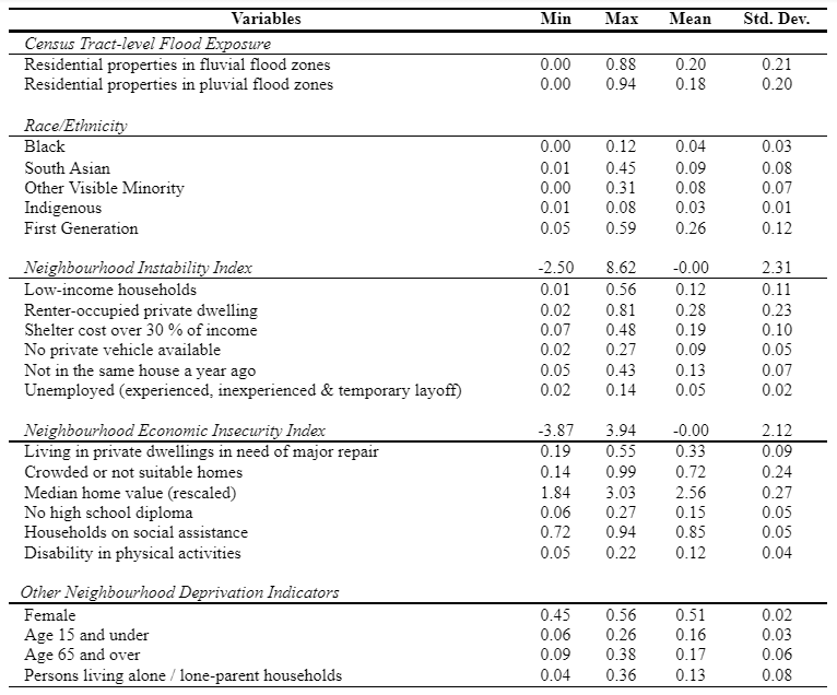
All variables in Table A.1 except owner-occupied home values represent census-tract-level proportions. The log of median home value variable is rescaled by subtracting census-tract-level individual values of the variable from its maximum value. The higher the difference between the highest value and census-tract-level particular value of the variable, the more severe and significant the neighbourhood-level socioeconomic deprivation the variable represents.
8. Appendix B: Principal component analysis
Following the methodology to construct a neighbourhood deprivation index (Messer et al., 2006), principal component analysis was applied with the Kaiser criterion on 17 standardized socioeconomic variables to identify significant neighbourhood deprivation indicators. Several other methods were used to examine multicollinearity problems, validity, and reliability of the dataset.18 As our selected census data passed all three diagnostics tests, we applied Principal component analysis on selected variables to extract independent componments, representing deprivation factors (Table B.1).
Table B.1. PCA Loading Scores and Post-Estimation
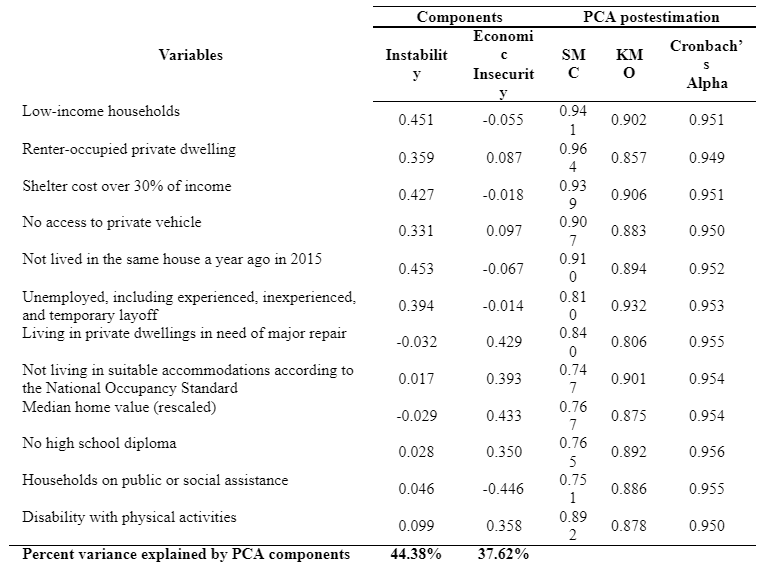
The data revealed that two deprivation components explained 82 per cent of the total variance. Since deprivation components and corresponding socioeconomic indicators increase socioeconomic vulnerability, a non-standardized socioeconomic vulnerability index (SoVI) was calculated by adding the absolute values of these components as suggested by Cutter et al. (2003) in the ‘hazard-of-place’ model of socioeconomic vulnerability (Guillard-Goncąlves et al., 2015). The index was then standardized, following the methods documented in Chakraborty et al. (2020), to rescale SoVI scores between 0 and 100 for ease of interpretation such that a SoVI score close to zero represents very low socioeconomic vulnerability and a SoVI score close to 100 indicates very high socioeconomic vulnerability. The index was then mapped using the choropleth mapping technique to visualize spatial disparities of socioeconomic vulnerability across census tracts in the Windsor CMA.
About the authors
Dr. Liton Chakraborty is a senior policy analyst in the Emergency Management and Programs Branch of Public Safety Canada. His research analyzes socioeconomic vulnerability, social inequities, and racial/ethnic disparities in environmental risks to consider gender-based analysis plus (GBA+) in federal decisions supporting equitable disaster and emergency management policy development for Canada.
Dr. Jason Thistlethwaite is an associate professor in the School of Environment, Enterprise and Development in the Faculty of Environment at the University of Waterloo, Associate Director of Partners for Action and Co-lead of the Climate Risk Research Group. His research focuses on innovative strategies to reduce the societal impacts of climate change and natural disasters.
Dr. Daniel Henstra is an associate professor of political science and co-lead of the Climate Risk Research Group at the University of Waterloo. His research focuses on the multi-level governance of complex policy areas such as climate change adaptation, emergency management, and flood risk management.
Footnotes
The ‘Two-Eyed Seeing’ of Cross-Cultural Research Camps
Published as part of our Indigenous Perspectives series featuring Indigenous-led initiatives to address and respond to climate change.
Summary
Climate change will hit the Northwest Territories (NWT) harder than most places in Canada. The Northern NWT has warmed more quickly than the rest of North America and the global average over the past 50 years, and scientists predict that the mean temperature will rise by between 4 and 8 degrees by the 2050s.
The changing climate threatens the health, safety, and food security of Indigenous communities such as the Sahtú. In an effort to deal with these changes, the Sahtú communities have turned to community-based traditional knowledge and science-based research and discussions as the basis for wise decision-making regarding what to do about climate change. The NWT government has also identified community-based monitoring and management as among the most important actions to inform decisions on potential adaptations.
Sahtú communities have turned to community-based traditional knowledge and science-based research and discussions as the basis for wise decision-making regarding what to do about climate change.
In the Sahtú, this type of work has been undertaken in the form of cross-cultural, on-the-land camps that create opportunities for learning and sharing across cultures, across generations, and across knowledge systems. This case study presents how this strategy has been successful in creating safe spaces for learning about the changes that everyone is seeing on the land in the face of climate change. It provides examples of what has worked during these camps, including:
- the building of relationships between community members and southern researchers;
- the learning and practicing of traditional skills such as fishing; and
- the learning and understanding of the land in their traditional territory.
It also identifies challenges that this work presents, including:
- the high cost of bringing people onto the land;
- designing schedules that keep all participants engaged; and,
- keeping people feeling safe and supported.
Context
The Sahtú Region is an area of 280,238 square kilometres—about the size of Ecuador and arguably the most ecologically diverse landscape in North America. It encompasses the world’s seventh largest freshwater lake, Sahtú (Great Bear Lake); portions of Shúhtaot’ı̨nę Nęnę (the Mackenzie Mountains), Canada’s longest river system, Dǝho (the Mackenzie River); and the transition between dechı̨ ta (taiga forest) and gokw’i (arctic tundra).
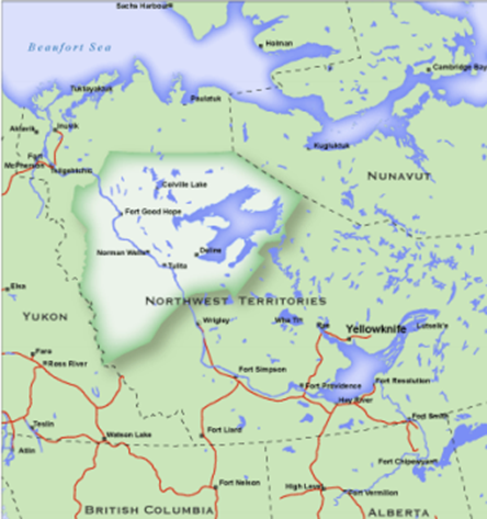
There are five communities of the Sahtú region: Délı̨nę, K’áhbamı̨túé (Colville Lake), Rádelı̨hkǫ́ (Fort Good Hope), Tulita (Tulít’a), and Tɬegó̜hɬı̨ (Norman Wells). The Sahtú population totals 2,500, approximately 1,800 or 70 percent of whom are Dene and Métis. Within these communities there are roughly three dialects encompassing six varieties of Dene Kedǝ, “Dene language,” (also known as North Slavey), reflecting the diverse histories of the historically nomadic Sahtú families. The landscapes are reflected in the naming of the peoples and their language variants, including: Dela Got’ı̨nę (End of the Treeline Dene), Dǝho Got’ı̨nę (Big River Dene, people of the Mackenzie River, the second largest river system in North America); Shúhtaot’ı̨nę (Mountain Dene, people of the Mackenzie Mountains), and Sahtú Got’ı̨nę (Great Bear Lake Dene).
The cultural diversity of the Dene and Métis peoples arises from the region’s landscapes. Families traditionally travelled seasonally on the land and today many families maintain or are seeking to rekindle their ancestral stewardship roles with specific areas.
The Sahtú Dene and Métis are resilient peoples, and have successfully adapted to significant environmental, cultural, and socio-economic changes throughout their history. However, climate change poses a new and significant challenge. Sahtú regional priorities related to climate change adaptation are well documented through a number of recent planning and research initiatives. For example, caribou populations have been decreasing or changing their patterns, which has led to two community conservation plans rooted in traditional Dene laws for sustaining relationships with caribou (Ɂekwe/ʔəde). These are Délı̨nę’s Belarewı́le Gots’ę́ Ɂekwę́ (Caribou for All Time) plan and Colville Lake’s Dehlá Got’ı̨ne ʔəde plan.
Any research in the Sahtú should follow both community-identified research priorities and support community leadership of and participation within that research. Some of the recent research initiatives are discussed below.
Community-Led Approaches
The principle that any research should be community-led is what initiated the Nę K’ǝ Dene Ts’ı̨lı̨ (Living on the Land) Forum, a name which emphasizes and articulates the integral link between land stewardship and Dene and Métis identity and wellness. The forum also followed the holistic approach of Sahtú communities by seeking to integrate research with programs that support land stewardship, Dene and Métis identity and wellness.
The Sahtú Renewable Resources Board is one of three co-management boards created by the Sahtú land claim agreement to manage the land wisely. The Board, along with other partners, has used the Nę K’ǝ Dene Ts’ı̨lı̨ Forum to help articulate community and regional research priorities as well as local and regional research governance. It is also used to provide opportunities for building local and regional research capacity to support the development of Indigenous talent, knowledge, partnerships for reconciliation, and respectful relationships.
The Forum invites academic researchers, territorial and federal government departments, and industry representatives with active or proposed research projects in the region to attend meetings and discuss their work, its benefits and implications. The Forum has established long-term collaborative relationships with a number of researchers from diverse institutions and disciplines, reflecting local values that recognize land stewardship as a complex topic inextricably linked to questions of culture, language, identity, economy, and wellness. The Forum’s purpose, as defined in its terms of reference, is “to provide advice and coordination support for traditional economy, on-the-land activities.”
Linked to the Forum is the actual on-the-land aspect, which the Sahtú Renewable Resources Board has coined Cross Cultural Research Camps. They follow a similar format to the Forum but are done on the land. The model aims to provide interactive experiences from on-the-land practices and dialogue with traditional knowledge holders combined with science-based research and monitoring techniques and methods. This “two-eyed seeing,” as it is sometimes called, brings a lot more significance and understanding to the discussions and decisions regarding land stewardship, climate change, and the connections the communities have to these areas. They also provide a greater learning environment for all involved.
The camps consist of participants from multiple generations, multiple cultural backgrounds, and different academic and knowledge-system backgrounds. This integration ensures culturally appropriate and holistic approaches that build environmental leadership; honour, foster, and mobilize Indigenous knowledge; support and involve family units including youth; and create opportunities to support Dene and Métis wellness, healing, land stewardship, and career development.
“The Board’s strategy included decolonizing, Dene Ts’ı̨lı̨, the other side of the same coin, also on-the-land orientation, so centred on the land as much as possible…we also have youth centred…those are key elements of the Board’s strategy. Oh, and community-driven conservation planning. That’s the approach.” —Deborah Simmons,Tulı́t’a
The Camps
The overarching goal of the camps is to create an environment where experiential, on-the-land learning helps to facilitate co-production of knowledge that is grounded in the traditional knowledge and experiences of community members. Community members, researchers, and partners use the time on the land to better integrate current and planned research initiatives, identify research and capacity needs, and support new and innovative research to address these concerns in the Sahtú. The collaborative nature of the camp’s activities is designed to add value to the research and to encourage open discussion and knowledge sharing between community members and researchers.
The overarching goal of the camps is to create an environment where experiential, on-the-land learning helps to facilitate co-production of knowledge that is grounded in the traditional knowledge and experiences of community members.
The Sahtú Renewable Resources Board has been holding these types of camps for nearly a decade and continues to learn how to improve them every time to allow for greater learning by participants, greater self determination by the Sahtú communities and simply more effective and efficient ways to share, communicate, live, and work together when out on the land.
Below are several examples of Cross Cultural Camps that have been hosted.
The Dene Ts’ıl̨ı̨School Experience: Toward a Sahtú Youth Network
In discussions with youth in the five communities, they expressed a need for more on-the-land opportunities. In particular, they wanted opportunities to be out on the land with elders for a longer period of time so that they are able to learn about the land and develop their bush skills. Three distinct intentions emerged through this dialogue: to 1) develop community capacity by involving local Ɂehdzo Got’ı̨nę (Renewable Resources Council) in the development and implementation of the Dene Ts’ı̨lı School; 2) strengthen the connections that youth have with their traditional culture; and 3) help to foster leadership skills among youth.
The camps were held at Dǝocha (Bennett Field) during 2017-2018. The first workshop gave rise to development of the cross-cultural Dechı̨ta Nezǫ Gots’udı́ (Living Well on the Land) approach to safety planning. The second workshop provided an opportunity to assess implementation of the plan’s first iteration, expanded the plan to include cultural and spiritual safety components, and focused specifically on safety planning for activities during the fall season.
In addition to the pre-camp planning workshops, daily leadership meetings provided time for the instructor team to discuss learnings from the previous day and refine the approach and plans for the coming day’s learning activities. Learning was necessary for both non-Indigenous resource people and elders/mentors. Non-Indigenous resource people are challenged to understand, respect and support spaces for learning that are tailored for Dene and Métis youth learning needs. Dene/Métis elders and mentors have a similar challenge coming from another direction, in that they seek to learn about the needs of young people who are at home in town and in structured school contexts, but are often unfamiliar with traditional ways of learning on the land.
“A major highlight for me was learning to appreciate my life, my loved ones, my culture, and food. I was dealing with depression this past year, and somehow Dene Ts’įlį school has helped me to move forward from that mental state of mind.”
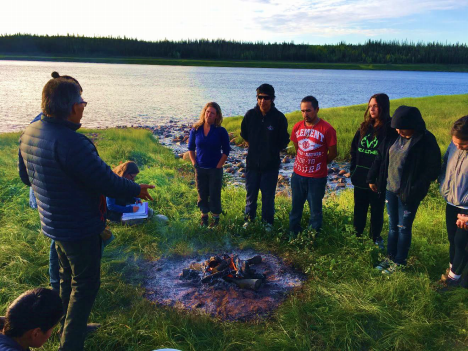
For thousands of years, Dene people across the Sahtú have had guidelınes and laws that were, and are, followed to stay true to the land, ancestors of the past and for people of the future. Trevor speaks about some of these Dene Laws that apply to the lifestyles of Sahtú people. Created by Trevor Niditchie at the February 2017 Dene Ts’įlį School. Dene people take great pride in being and knowing they are from the land. In order to be healthy Dene people, therefore, it is important to ensure that the land is also healthy and prosperous. Created by Shannon Oudzi at the September 2017 Dene Ts’įlį School.
Water Knowledge Camps: Building Capacity for Cross-Cultural Water Knowledge, Research, and Environmental Monitoring
The Dene and Métis people of the Sahtú region experience a strong connection to the waters that surround them, and have a strong interest in scientific research and monitoring activities in their territory as evidenced by many years of participation in science-based research. However, notwithstanding scientific research results, communities throughout the Sahtú have expressed concerns about the health of the waters in the region (and consequent risks to human health) due to the legacy impacts of mining and development in the region and beyond, including Port Radium and oil and gas development in Norman Wells, long range transmitted contaminants, upstream effects of oil sands development in Alberta, and more recently the impacts of climate change and the potential for development of the Canol shale oil and gas play. As a result, many have stopped drinking from local water sources, preferring to purchase drinking water imported from elsewhere. With a great deal of research being conducted in the Sahtú, it was critical to promote a common cross-cultural understanding of water knowledge and concepts of risk by both researchers and community members as a basis for wise decision-making and community-based risk communication. Furthermore, there was a strong desire to build greater capacity for community-driven research and monitoring and ensure that research is conducted and results delivered in a culturally and socially respectful manner.
The first Water Knowledge Camp was held at the junction of Sahtú Dǝ́ (Great Bear River) and Tek’áı́cho Dǝ́ (Marten River) in Tulı́t’a, NWT, from August 19-26, 2019. It was an opportunity for Dene and Métis people of the Sahtú and academic researchers to come together on the land to share knowledge about water, climate change, and environmental monitoring. The objectives of the Water Knowledge Camps are to:
- Promote knowledge sharing between researchers and communities in the Sahtú.
- Hold focus groups with community partners to enhance effective communication of water-related research results to communities.
- Establish new baseline water quality and environmental research monitoring sites and work with communities and partners to build a water quality and environmental monitoring framework for the region.
Although the activities varied daily, they included daily chores, fishing (a favourite among the youth), berry picking, making dry-fish, preparing moose ribs, quilling, singeing, and cooking a porcupine that had wandered into camp, collecting spruce boughs, and beading. These experiential activities, facilitated by community members, had value for all participants because they learned how to be on the land and were taught about the cultural significance of being Dene and their holistic relationship with the lands, waters, wildlife, and community.
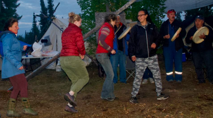
Research activities offered another form of experiential learning. Three concurrent focus groups were held on drinking water, environmental monitoring, and climate change. At the request of the youth, the climate change focus group was amended to include a discussion on youth leadership. Additional research activities included a water sampling and data collection/management demonstration facilitated by the Ministry of Environment and Natural Resources, a tree coring and cookie activity, a mapping activity, and collecting water samples from Great Bear River.
“We are here at this camp to teach the young people the importance of water and to teach them about the science of water. Not only from new visitors from the south, researchers and scientists, but we also talk to them about traditional knowledge, about Dene knowledge, what our ancestors and our prophets have predicted. So, we are combining the two.” – Michael Neyelle, Délı̨nę
“Máhsı to the elders for passing on their knowledge and teachings to me. It’s because of you I can become a respectful Indigenous woman. Without programs like these, I would have never learned anything. I didn’t have family that took me out on the land. I didn’t have anyone to teach me these things. That’s why we need more programs like this for the youth. We need to make a difference.” -Kyanna Lennie-Dolphus, Tulı́t’a
Tracking Change Project
Since 2016, communities in the Sahtú have taken part in the Tracking Change project, which focuses on environmental changes in and around the Dǝhogá (Mackenzie River) through hands-on activities, participant sharing, and interpreted traditional knowledge about the changing ecology of water and fishing livelihoods. The long-term goal of this project in the Sahtu is to strengthen the voice of Indigenous communities in the governance of the Mackenzie River. Their local and traditional knowledge can help us all understand and interpret the long-term patterns of both cultural and ecological changes and the interconnections between the well-being of the river system and community.
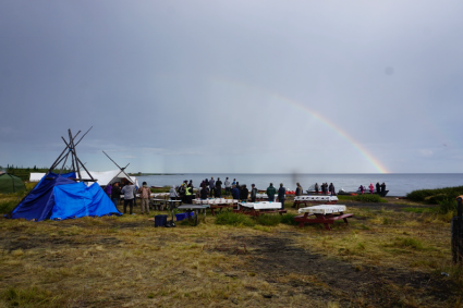
Fish has always been a food staple for communities of the Sahtú region, available when other luxury foods like caribou and moose are scarce. However, ongoing climate related changes are raising newfound concerns about the future of fishing and fishing livelihoods. In 2016, Délı̨nę Got’ı̨nę community members participated in a pilot year with the Tracking Change project which focused on possible environmental changes in and around the Great Bear Lake region. In 2017, a similar camp was held by the Tulı́t’a Got’ı̨nę community, and finally in 2018, similar questions were explored during the Lafferty family’s annual fish camp downriver in the K’áhsho Got’ı̨nę district, with an emphasis on changing approaches to cross-generational education practices for maintaining necessary knowledge and skills in fish harvesting, preservation, and sharing.
Through hands-on activities, participants shared and interpreted traditional knowledge about the changing ecology of water and fishing livelihoods. Activities addressed five main objectives:
- to document narrative and practice-based systems for cross-family, cross-community, and cross-generational transfer of traditional knowledge and skills in water safety, subsistence fishing, fish preparation, and the sharing economy;
- to document traditional knowledge narratives and spatial information about water and fish ecology
- to strengthen planning processes for traditional knowledge research and monitoring;
- to strengthen community governance and leadership in water stewardship and fish conservation; and
- to foster networking and collaboration in ongoing and new community-driven traditional knowledge research and monitoring in the region.
Participants left with a greater understanding of traditional fishing practices, fish and water ecology and how it has changed over the years, and a new set of skills in traditional fishing practices. Semi-structured interviews were conducted in order to explore the climate change-related impacts on water, fish, fish health, and well-being. Grounding research and monitoring in community-driven conservation processes ensure projects themselves become avenues for knowledge mobilization and reconciliation and are embedded within strengthened governance models directly involving decision makers.
Camps in the time of COVID
This last year following the outbreak of the COVID-19 pandemic, the Sahtú Renewable Resources Board, just like every other organization, has had to re-orient and strategize on how to continue to do their work. For us, we were able to create community bubbles and hold more Nę K’ǝ Dene Ts’ı̨lı̨ Forum calls within and between communities while virtually bringing in our partners from outside the territory so that nobody felt like the work had stopped. One project concerning food security and the impact of climate change in the community of Tulı́t’a was coming to a close. Originally, several community members were meant to travel to the University of Waterloo to participate in cross-cultural exchanges and to learn how the data analysis was done on the data they had collected. With travel restrictions, this was not possible. We therefore came up with a plan that permitted cross-cultural exchanges at a distance and short-term employment for the local group of the Shúhta Ne K’édíke (Keepers of the Mountain Land), a group of young Indigenous Guardians.
The Shúhta Ne K’édíke Program contributes to community health and well-being, sustainable economic development and expanded employment, food security, strengthened local governance and reconciliation, and cultural and spiritual integrity. It is helping to build resilience through land-based stewardship, drawing on traditional knowledge and science to understand and build adaptive strategies for climate change, and other socio-ecological changes affecting our peoples. Initiatives are locally led with the goal of restoring active Indigenous stewardship of traditional lands and encouraging and supporting communities to re-assert their traditional land steward roles. The program also provides participants with critical decision-making information that the communities can use when deciding on future research, industrial or extractive projects as well as in policy and regulation discussions with various levels of government.
The project started by sending these Shúhta Ne K’édíke along with some mentors onto the land to harvest country foods for the workshop and see firsthand the impacts that climate change has had on their land and on country food availability. The vicious cold and heavy snowfall that they faced taught them how to survive and how the weather affects how the animals behave. With no large or small game to be found, they focused on fishing and brought them back to the community.
While no one from outside the territories could join, we were able to prepare great communication materials in the form of easy-to-understand posters to host a workshop that focused on teaching youth and other community members how to prepare the fish in a way that preserves it and reduces wastage. At the same time, we were able to discuss the importance of teaching the community these skills because climate change has made going out on the land less predictable, more expensive and also less likely to yield successful harvests. It was also an opportunity to talk about the results of the research conducted, which supported what the community traditionally did, sharing traditional foods amongst one another to ensure that the community remained healthy.
Lessons Learned
Each on-the-land camp comes with new obstacles, new understanding, and new fun. It has become clear that in order to truly get cross-cultural knowledge sharing there is the need for deliberate and strategic approaches to teaching the participants, especially the youth.
The first major lesson that was learned and has since been incorporated into every camp was the need for wellness supports in on-the-land programs, especially those that include or target youth. Many Sahtú youth are struggling with addictions, intergenerational impacts of residential school and colonialism, and related experiences of trauma or stress. Leadership team members also struggle with these same challenges. Living on the land is not in itself a path to wellness, as is often assumed. In fact, being on the land can be triggering—and people continue to be affected by what happens in town. People taking leadership responsibility at camps for youth in the Sahtú need to be trained in wellness skills to appropriately address issues that are sure to come up. Moreover, training is also needed to support youth to be well upon returning to town.
The second major lesson is not to assume that everyone knows how to spend time on the land safely. Our first camp gave rise to development of the cross-cultural Dechı̨ta Nezǫ Gots’udı́/Living Well on the Land approach to safety planning, which includes cultural and spiritual safety components. Every camp since has been an opportunity to assess the implementation of the plan and add in new information and learnings that come out of the camp. The latest camp held this winter has now made us realize that we need to have a rule on when travel is not safe during the winter in particular, for example anything colder than -40 degrees Celsius.
The safety planning process has served as invaluable spaces for leadership development, since collaborative safety planning requires collective development of the program approach and activities. In addition to the pre-camp planning workshops, daily leadership meetings at the camp provide time for the instructor team to discuss learnings from the previous day and refine approach and plans for the coming day’s learning activities. These leadership meetings are done in a self-determined way, and anyone in the camp who wishes to join and take on a leadership role, even if only for a day, is welcome. We have found this to be an incredibly useful and rewarding format, as we have found youth who want to join and bring new ideas to the table and take on this leadership role.
A third lesson from these camps was the realization that it’s not enough to just be living together on the land but that there is the need to create a conducive learning environment. Camps need to include some structured learning, but also leave considerable time for less structured Dene ts’ı̨lı̨ activities as well such as fishing, harvesting, berry picking, sewing, etc. For the youth, it is important to have both cultures represented because they are straddling both and need opportunities to learn both and reconcile that within themselves. Therefore, though elders may not find learning about drones interesting, combining learning on how drones can be used to understand how the land is changing with the stories from the elders and actually walking the land provides youth with a full understanding of different ways of looking at and understanding their territory.
In this same vein, the participants, especially the youth again, are also looking for skills that will help them get jobs. It is important to provide training sessions that result in certificates. For example, firearms training, chainsaw safety, and wilderness first aid certificates. These certificates are also helpful in terms of recruitment of participants. It continues to be a challenge to recruit participants for the camps for various reasons, including childcare, addictions, anxiety—both of leaving their families but also being on the land—and peer pressure. As the camps have continued, it is getting easier, and knowing that there is something concrete such as a certificate at the end of the training that can help with employment is one of the incentives.
One of the greatest benefits of these camps is the positive and supportive relationships established at them. For months and year afterwards, that relationship continues, and people talk about the camps as a “community” or “like family.” They have led to much better relationships between researchers and community members as both begin to see how the others think and what is important to them and why. It has led to better relationships between Sahtú Renewable Resources Board staff and community members and researchers, which has meant easier recruitment and participation in all the Board’s work, as well as more funding from donors who have been part of the camps.
The camps have also led to better relationships among community members themselves. One of the training camps held in the summer of 2020 brought together youth from Tulı́t’a and Norman Wells, NWT, and they continue to stay in touch, meeting to talk about the camp and come up with plans for future activities. Another camp, in the summer of 2018, gave grandparents a chance to take their children and grandchildren with them onto the land and just be with each other and share in a healthy, uncomplicated way for two weeks.
These relationships that are built at the camps support and build cross-cultural, cross generational understanding. These relationships are what the Sahtú Renewable Resources Board feels will build up the region, because it is by drawing on traditional knowledge and science that the communities will be able to build adaptive strategies for climate change, make decisions that support their Dene ts’ıl̨ı̨, and ensure that the communities have the support they need to stay resilient in the face of all the changes coming their way.
“There’s a lot of work that we do here, and I would like to thank the young guys and everybody who pitched in. It really helps a lot. Like I said, from day one, I really like it here with everybody here. It brings my spirit back up. That’s what we’re here for. We are on the land, and we really connect ourselves to the land and our spirituality is so important for me and everybody too. Every day we learn something new. We learn from different cultures, how they do stuff and how we do our traditional stuff. It helps us to grow and to understand. I think someone said that’s for the young people here. Keep doing what we’re doing here. I would like to thank Debbie and the crew from the university that came here to put this program on. It’s really good. I hope we have more of this here. We always talk about the young generation and we are here to teach them and to show them the right way, the right path. Máhsı.” – Wilbert Menacho, Tulı́t’
About the Authors
Kirsten Jensen has worked in conservation for nearly a decade, much of it spent learning from other cultures how they want to protect their special places. Her time with the Sahtú Renewable Resources Board has focused on getting community members on the land and learning the skills they want to learn from their elders and western science while also making sure that they have a voice in the decisions being made about their land.
Deborah Simmons is the Executive Director of the Sahtú Renewable Resources Board. She was raised in the Northwest Territories and is trained as a social scientist specialising in social and environmental issues relating to Indigenous peoples.
Leon Andrew is a Shúhtaot’ı̨nę elder with the Tulı́t’a Dene Band. He is the Sahtú Renewable Resources Board’s Research Director. Leon has provided his research expertise on numerous traditional knowledge studies, assisted and advised GNWT Archeologists from the Prince of Wales Museum, and is also an experienced interpreter in Dene and English languages.
Climate Change impacts on bees in Mi’kma’ki
Published as part of our Indigenous Perspectives series featuring Indigenous-led initiatives to address and respond to climate change.
Although smaller than a thumbnail, bumblebees play an outsized role in our food system and our ecosystem health more broadly. In this case study video, Gregory Dugas, an Indigenous youth from Mi’kma’ki (Nova Scotia), shares his experiences about protecting and rearing bumblebees as part of “Protect the Bees in Mi’kma’ki,” an initiative of the Confederacy of Mainland Mi’kmaq’s Climate Action Program.
Gregory explores how surging pest populations are linked to warmer weather from climate change (among other factors) and the devastation these pests, such as wax moths, have on bumblebee colonies. Based on his field research, Gregory suggests the provincial government implement a pilot project to install “cat flaps” on managed hives to reduce the threat of pests and preserve bumblebee populations.
Gregory Dugas is a youth beekeeper who is passionate about the stewardship of bumblebees, honey bees, and native bee species. He is a resident of Nova Scotia and lives near his home community of Millbrook First Nation.
Environmental Racism and Climate Change: Determinants of Health in Mi’kmaw and African Nova Scotian Communities
Summary
The health of each person across Canada is shaped by the economic and social circumstances of their life. In the coming years, the health of people in Canada will also be shaped by the impacts of climate change, such as rising temperatures, air pollution and climate hazards.
Climate change adaptation policy does not regularly reflect a key concept: that climate change impacts are not equitable, and that most risks are created by society, not the physical environment.
In order to develop more robust and equitable climate policies, it is important that decision makers understand how climate impacts, environmental racism, and structural determinants of health intersect to shape health and well-being, especially in Indigenous, Black, and other racialized and marginalized communities.
This case study illustrates how structural determinants of health are interconnected with climate change vulnerability and environmental racism in two Nova Scotia communities: African Nova Scotians and Mi’kmaw.
Introduction
In the coming years, climate change will increasingly have negative impacts on people’s health across Canada. In order to reduce these health impacts—which communities are already starting to experience—evidence-based adaptation policies are needed. However, adaptation policies are not always as rigorous and evidence-based as one would hope.
Climate change adaptation policies in Canada tend to neglect two important concepts. First, climate change impacts are not equitable, meaning most risks are created by society, not nature. Second, the main determinants of health are, in fact, caused by structural factors such as race, immigrant and refugee status, poverty, education, food security, and access to clean air, water, and soil.
Consideration of how structural determinants of health, climate impacts, and environmental racism intersect to shape health and well-being is key to developing robust climate policy and building greater resilience.
In this case study, I highlight some of the most pressing structural determinants of health in Mi’kmaw and African Nova Scotian communities, drawing on literature and case studies from the research and advocacy I have been involved in with these communities over the last nine years.
The communities profiled in this case study are illustrative of a broader story of racism, health inequality, and the impacts of climate change, which will play out not only across Nova Scotia but across Canada. The stories and findings from these communities help to articulate the relationships among climate change and racial and class inequality.
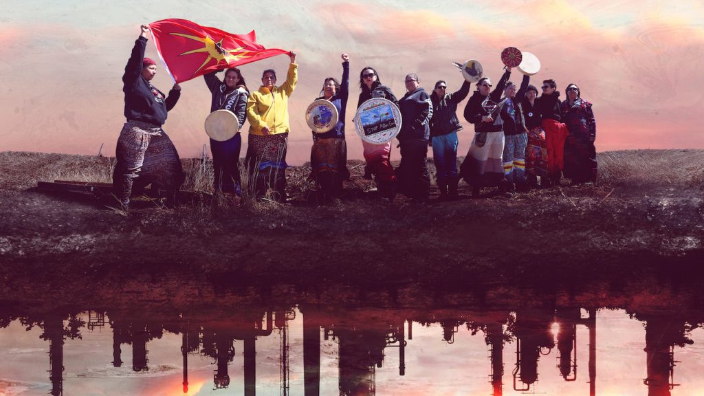
Structural determinants of health impact climate change sensitivity
The concept of the structural determinants of health is increasingly being used to refer to the social, economic, political, and environmental conditions that contribute to illness and disease (De Leeuw, Lindsay & Greenwood, 2015; Waldron, 2018a, 2019). The concept of structural determinants builds on the idea of social determinants of health, which is that health is shaped by an individual’s material circumstances, such as living and working conditions (Davidson, 2015). A structural determinants framework takes a more systemic focus. The material conditions of health are rooted in systems outside an individual’s control (economic and social policies, the justice system, etc.) that have historically discriminated against racialized and marginalized people (De Leeuw, Lindsay & Greenwood, 2015; Waldron, 2018a, 2019).19 For example, lack of access to medical care in rural African Nova Scotian communities until the late 1930s, a legacy of diseases contracted by early African settlers, and racial discrimination dating back to slavery in Nova Scotia contribute to ongoing health disparities between African Nova Scotians and other populations.
“Income makes you healthy. Because I notice when you live in poverty, you tend to not be able to eat well or afford your prescriptions. And that happens a lot with the seniors in the community. So, if there are no jobs available, how are they going to eat tomorrow or how are they going to support their families and themselves and make sure they have okay health if they can’t get their medicine? And that also causes depression, and it causes anxiety and stress. And stress does bother you and it does kill you.”
In a study conducted recently, a participant from the African Nova Scotian community of Lincolnville discussed the relationship between health and poverty, food security, employment, and access to health services (Waldron, 2016).
Income and employment are key structural determinants of health because they influence access to adequate housing, healthcare, and food. Both Mi’kmaw and African Nova Scotian communities experience higher poverty rates and income instability. Frank and Saulnier (2017) report that poverty rates tend to be higher in predominately African Nova Scotian communities, such as East Preston and North Preston, where 38.9 per cent and 40 per cent of families, respectively, live in poverty. The unemployment rate for Mi’kmaw people living on reserve in the 2006 census was 24.6 per cent, compared to 9.1 per cent for all Nova Scotians (Office of Aboriginal Affairs n.d.; Statistics Canada 2011; Waldron, 2018a).
Criminalization and discrimination through the justice system are part of the social and economic conditions that influence health. Between 2014 and 2015, about 12 per cent of youth sentenced to a youth correctional facility and seven per cent of adults sentenced to jail were Mi’kmaw – although Mi’kmaw people represent only about 4 per cent of the total population (Luck, 2016). The 2019 Wortley Report on street checks revealed that African Nova Scotians were six times more likely to be stopped by police than white people (Wortley, 2019). Higher rates of criminalization are informed by racist stereotypes and result in racism and violence directed towards racialized people at all stages of the criminal justice system. Incarcerated people in Canada have higher rates of many negative health outcomes, such as mood disorders, communicable diseases, and mortality, especially death by suicide (Kouyoumdjian et al., 2016).
Education is strongly connected to employment and income security and, consequently, to the ability to access the resources that contribute to health and well-being, such as food security and housing security. Mi’kmaw and African Nova Scotians are less likely to finish high school or attend university than other Nova Scotians. Of African Nova Scotians aged 25–64 years, 77.7 per cent have some sort of certificate, diploma, or degree, compared to 85.3 per cent of all Nova Scotians (African Nova Scotian Affairs n.d.). Twelve per cent of the Mi’kmaw population between the ages 25–64 holds a university degree, compared to 20 per cent in the general population (Office of Aboriginal Affairs n.d.; Statistics Canada 2011).
It is also becoming more widely recognized that stress and trauma from racism itself negatively impact the health and well-being of racialized people, even in the absence of other risk factors (McGibbon, Waldron & Jackson, 2013). The Canadian Public Health Association states that systemic racism, although subtle, causes harm in every aspect of life and is correlated with poorer health outcomes for racialized communities, such as hypertension, infant low birth weight rate, heart disease, diabetes, and mental health (CPHA, 2018).
Structural inequities like poverty and discrimination contribute to poor health outcomes for many racialized and marginalized people. Poor overall health, in turn, makes these communities more susceptible to the negative health impacts of climate change.
Structural determinants impact exposure to climate hazards
Indigenous, Black, and other marginalized communities in Canada and around the world are more exposed to the impacts of climate change (Simmons, 2020). They are more likely to reside in places where they are impacted by poor air quality and water contamination from polluting industries, as well as future climate devastation resulting from rising sea levels, raging storms and floods, and intense heat waves (United Nations, 2019).
Environmental racism helps to explain the unequal impacts of hazards. Environmental racism is the idea that marginalized and racialized communities disproportionately live where they are affected by pollution, contamination, and the impacts of climate change, due to inequitable and unjust policies that are a result of historic and ongoing racism and colonialism (Konsmo & Kahealani, 2015; Pulido, 1996). Furthermore, marginalized communities often lack political power for resisting the placement of industrial polluters in their communities through their exclusion from many environmental groups, decision-making boards, commissions, and regulatory bodies (Cryderman et al., 2016; Deacon & Baxter, 2013; Scott, Rakowski, Harris & Dixon 2015; Waldron, 2018a, Waldron 2018b).
Epidemiological studies increasingly link diseases like cancer, skin conditions and reproductive health in Indigenous, Black, and other racialized communities to their disproportionate exposure to pollutants, contaminants, and climate hazards. The ENRICH Project map, developed by my research team, identifies different polluting industries and other environmental hazards in Mi’kmaw and African Nova Scotian communities across Nova Scotia, demonstrating the proximity of waste incinerators, waste dumps, thermal generating stations, and pulp and paper mills near these communities, as well the harmful materials contained at these sites that are linked to health risks.
A feedback loop exists between exposure and sensitivity
Structural determinants of health and environmental racism are deeply connected. These two factors work together to make racialized and marginalized communities more exposed and more sensitive to the impacts of climate change.
Racist and colonial legacies have created lasting health inequities in many marginalized communities, making them more sensitive to climate impacts. Further, because of environmental racism, many marginalized communities will be more exposed to climate hazards that could affect their health.
Recognizing and addressing how structural health inequities and environmental racism make marginalized communities more vulnerable to the impacts of climate change can make for stronger, more equitable climate policy.
The following sections examine some of the most significant structural determinants of health in Mi’kmaw and African Nova Scotian communities that result from social, economic, political, and environmental inequities.
Structural Determinants of Health in Mi’kmaw Communities
The Mi’kmaw, or Lnu, are the founding people of Mi’kma’ki (what is now known as Nova Scotia), having existed in the province for over 11,000 years (Sipekne’katik n.d a). The Mi’kmaw land stretches from the Canadian Maritimes to the Gaspé Peninsula in Quebec (Sipekne’katik n.d.a). It is comprised of thirteen bands/First Nations, each of which is governed by a chief and council. The largest of the thirteen bands in Nova Scotia are Eskasoni (4,314 members) and Sipekne’katik (2,554 members) (Indigenous and Northern Affairs Canada, 2014; Sipekne’katik. n.d.b).
Structural inequities within education, employment, criminal justice, the environment, and other social structures contribute to poor health and mental health outcomes in Mi’kmaw communities in Nova Scotia and other Indigenous communities in Canada.
Land use planning and development policies have resulted in Mi’kmaw communities being disproportionately exposed to polluting industries and other environmental hazards. There have been several cases of environmental racism in Mi’kmaw communities in Nova Scotia, which are highlighted in this section.
Sydney, Cape Breton
The Sydney Tar Ponds was a hazardous waste site on Cape Breton Island that sparked some of the first concerns about environmental injustice in Canada. The estuary at the mouth of the Muggah Creek where it joins Sydney Harbour used to be a hunting and fishing ground for the Mi’kmaw. From 1901 through 1988, Sydney Steel Corporation’s now decommissioned steel mill operated in the area with no pollution controls. Over a million tons of particulate matter were deposited and several thousand tons of coal tar were released into the estuary over that period, including chemicals known to cause cancer (Lambert, Guyn, and Lane 2006). As a result, Sydney area residents experienced a local cancer rate 45 per cent higher than the Nova Scotia average, and the highest rate in Canada (Nickerson 1999).
The Sydney Steel Corporation produced significant amounts of toxic waste, yet very little money was invested to modernize the facilities or to address the health and safety concerns of the workers (Campbell, 2002). In 1974, Environment Canada found that air pollution from the coking operations was 2,800 to 6,000 per cent higher than national standards allowed (Barlow and May, 2000). As Campbell (2002) documents, there were several attempts over the years to remediate this former industrial site. Concerns were raised in 1980 about the need to address the environmental risks of steelmaking in Sydney after the federal fisheries department discovered that lobsters in Sydney Harbour had high levels of carcinogenic chemicals and various toxic metals such as mercury, cadmium, and arsenic (Campbell, 2002).
In May 2004, the governments of Canada and Nova Scotia announced that they would commit $400 million over the next ten years to remediate the Sydney Tar Ponds site to reduce the ecological and human health risks to the environment (Walker, 2014). The cleanup was completed in 2013 with the development of Open Hearth Park, which is situated on the site of the former steel plant (Morgan, 2015).
Pictou Landing First Nation
Boat Harbour, a quiet estuary near Pictou Landing First Nation, was once a fertile hunting and fishing ground until 1967, when an effluent treatment facility for the Northern Pulp mill started discharging pulp and paper mill biproducts into Boat Harbour under a provincial agreement (Idle No More 2014; Thomas-Muller 2014; Waldron, 2018a). The ecological and health costs associated with the dumping of billions of litres of untreated effluent and other industrial contaminants into Boat Harbour have been considerable. Boat Harbour has the third-highest cancer rates per capita of all health districts in Canada (Mirabelli & Wing 2006; Soskolne & Sieswerda, 2010). Other studies have concluded that there is a likely connection between the mill and high rates of respiratory disease in Pictou Landing (Reid, 1989). In addition to respiratory illness, the incidence and abundance of other health problems such as nose bleeds and cancers can also be partly attributed to years of bleached kraft pulp mill pollution (Reid, 1989).
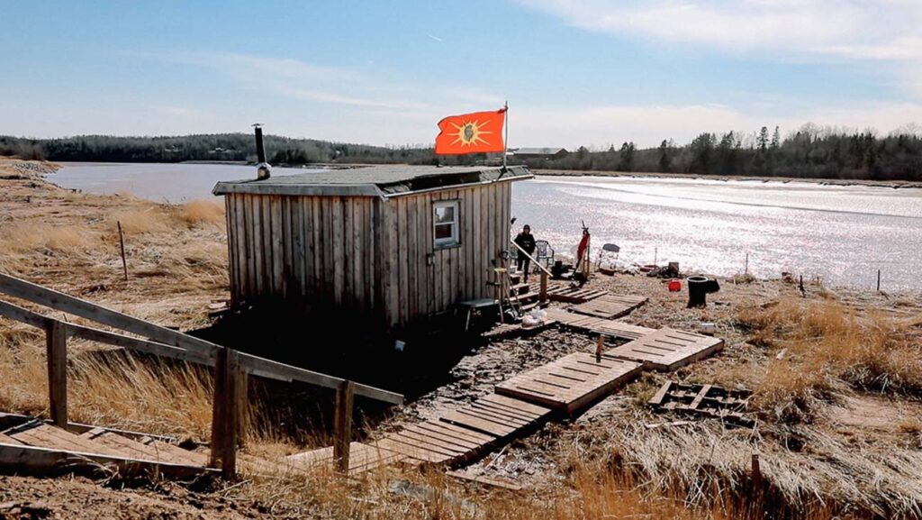
Sipekne’katik First Nation
Sipekne’katik First Nation in Hants County near Shubenacadie, Nova Scotia, is currently opposing the development by Alton Natural Gas Storage of a brine discharge pipeline next to the Shubenacadie River (Hubley, 2016; Waldron, 2018a, 2021). The brine discharge pipeline would allow natural gas to be stored in underground salt caverns near the Shubenacadie River. Failure rates for salt cavern liquid natural gas projects have been high in the United States and are considered dangerous due to risks of explosion, leaks, and emissions of gasses like methane (Howe, 2016; Hubley, 2016).
In the fall of 2014, Alton Gas began developing the brine discharge pipeline, but halted the project as local resistance grew. The project resumed in January 2016, after Alton Gas was given environmental approvals for several permits by the Government of Nova Scotia (Nova Scotia, 2016; Waldron, 2018a, 2021). Throughout 2016, resistance to the project grew even stronger. Members of Sipekne’katik First Nation argued that they were not adequately consulted, that they had never given consent for the project to resume, that they were not given enough time to review project proposals and environmental impact assessments, and that they were provided with little to no notice about public meetings where they could express their concerns about the project before it resumed (Howe, 2016; Hubley, 2016). In March 2020, a Nova Scotia judge overturned the approval for the project and ordered Alton Gas to continue consultation with Sipekne’katik First Nation (Grant, 2020).
In addition to concerns about the Alton Gas project, Sipekne’katik First Nation has been concerned for some time about contaminated water in their community. The community had access to clean water until 2012, when the community’s water table was contaminated by digging at the nearby Nova Scotia Sand and Gravel pit. During a meeting I held in 2014 (Waldron, 2014), residents spoke about the environmentally hazardous methods used by Nova Scotia Sand and Gravel to dig up and clean sand in the area. This involved digging down to the level where the community’s water table flows, resulting in the water table flowing into their site, as well as huge reservoirs of water the community was no longer able to use. The community was subsequently issued a do-not-drink advisory, after which the Department of Aboriginal Affairs began shipping water into the community. Despite this, the root cause of the problem — the pit located in the community’s backyard — was never addressed, resulting in ongoing issues with water contamination (Donovan, 2015; Waldron, 2014).
Acadia First Nation
Acadia First Nation in Yarmouth, Nova Scotia, is in the southwestern region of Nova Scotia. During a meeting I held in the community in 2013, residents expressed their concerns about the health risks associated with the junkyard in their community:
“Well, in our community, our reserve is actually built on a dump, over a dump. So, when they were digging it up, trying to loosen up all of the soil, so that I could put fertilizers on it and whatnot, we actually dug up car parts that are underneath us, and I was getting some history on this. So, when the band bought that land, they bought toxic land. I don’t know what they paid for it at the time, probably three-quarters of a million dollars, I don’t know, but anyway, all that land the band bought was used for a dumping zone, for cars, it was hundreds of cars where all the housing is right now” (Waldron, 2014; Waldron, 2018 a).
The junkyard has been used as a dumping ground for car parts for over sixty years and is a source of anxiety for residents, who believe it is associated with high rates of cancer in their community (Waldron, 2014).
Sydney, Pictou Landing, Sipekne’katik and Acadia First Nations are just a few examples of the larger phenomenon of environmental racism in Nova Scotia and Canada. Climate change could impact Mi’kmaw communities in the same way that environmental racism does: by increasing the exposure of marginalized communities to hazards. Increased exposure then undermines overall health and well-being in these communities, making them more vulnerable to future impacts.
The following section highlights similar examples of environmental racism among African Nova Scotian communities.
Structural Determinants of Health in African Nova Scotian Communities
People of African descent have lived in Nova Scotia for almost three hundred years, longer than any other Black community in Canada. African Nova Scotians are descendants of African slaves and freedmen, Black Loyalists from the United States, the Nova Scotian colonists of Sierra Leone, Maroons from Jamaica, and refugees of the War of 1812. The majority of African Nova Scotians and other people of African descent continue to reside in rural and isolated communities due to institutionalized racism during the province’s early settlement (Black Cultural Centre for Nova Scotia n.d.; Waldron, 2018a).
Over the past 70 years, environmental racism has damaged the health of rural African Nova Scotian communities. African Nova Scotians who live near toxic sites believe that high rates of cancer in their community can be linked to these sites. In my research, I have found that African Nova Scotian communities in Shelburne, Lincolnville, and the Prestons attribute high rates of cancer, liver and kidney disorders, diabetes, heart disease, respiratory illnesses, skin rashes, and psychological stress to various environmental hazards that have been near these communities for decades (Waldron, 2014, 2015, 2016; 2018a; 2018b, 2020a, 2020b, 2020c, 2020d). The following sections highlight specific cases of environmental racism in African Nova Scotian communities, including its impacts on health.
Africville
Perhaps no other African Nova Scotian community has served as more of a classic example and symbol of segregation, racism, and environmental racism than Africville. The community was located just north of Halifax on the shore of the Bedford Basin, and was first settled in the mid-1800s by Black refugees who came to Nova Scotia following the War of 1812 (Allen n.d.; Fryzuk 1996; Nelson 2001; Waldron, 2020d). The community was subjected to injustices on many levels. For example, although the City of Halifax collected taxes in Africville, they did not provide the community with basic utilities or infrastructure offered to other parts of the city, such as paved roads, potable water, sewage, public transportation, garbage collection, recreational facilities, fire protection, streetlights, or adequate police protection (Allen n.d.; Fryzuk 1996; Halifax Regional Municipality n.d; Nelson 2001; Tavlin 2013; Waldron, 2020d).
Starting in the 1800s, the city placed a number of undesirable facilities in Africville, such as slaughterhouses, an infectious disease hospital, and human waste disposal pits (Mackenzie, 1991). In 1947 the city rezoned Africville as industrial land. The rezoning permitted the construction of an open-pit dump in 1950, which many in the community considered to be a health hazard (Waldron, 2018a). In 1964, the City Council voted to relocate Africville residents in order to build industry and infrastructure in the area. By 1970, all homes in Africville had been bulldozed and residents forcibly displaced into other areas of the city (Waldron, 2020d). Africville subsequently became host to several environmental hazards, including a fertilizer plant, a slaughterhouse, a tar factory, a stone and coal crushing plant, a cotton factory, a prison, and three systems of railway tracks (Allen n.d.; Fryzuk 1996; Nelson 2001; Waldron, 2018b, Waldron, 2020d).
Shelburne
The Morvan Road Landfill has been located near the African Nova Scotian community in South Shelburne since the 1940s (Waldron, 2020d). The landfill was used for industrial, medical, and residential waste until its closure in 2016, thanks to pressure from the community (Waldron, 2018a). While the closure of the landfill is a major achievement, the presence of the landfill continues to have health and environmental repercussions in Shelburne. The waste that accumulated has not been addressed through a remediation plan (Delisle & Sweeney, 2018). A Shelburne resident who participated in my study on environmental health inequities in African Nova Scotian communities attributed high rates of cancer and liver and kidney disorders in her community to the landfill near her community.
Lincolnville
Lincolnville is another example of a long-standing case of environmental racism in an African Nova Scotian community. Lincolnville is a small rural African Nova Scotian community situated in Guysborough County in northeast Nova Scotia. It was settled by Black Loyalists in 1784 (NSPIRG n.d.). In 1974, a first-generation landfill was opened one kilometre away from the community (Waldron, 2018a). The health impacts of the first landfill are unknown, though residents believe rates of cancer in the community are far above acceptable levels (Waldron, 2018a).
“Everyone knows that in all surrounding communities the dump can be seen in the south end of the community. A significant amount of people in proximity to the dump has died from cancer and has or is suffering from an array of other health problems such as various forms of cancer, increased blood pressure, changes in nerve reflexes, brain, liver, and kidney disorders” (Waldron, 2016).
In 2006, the Municipality of the District of Guysborough closed the first landfill and opened a second-generation landfill at the site of the first-generation landfill that accepts waste from across northern Nova Scotia and Cape Breton. According to regional environmental organizations, hazardous items such as transformers and refuse from offshore oil spills have been deposited at the landfill. This has caused concern in the community about unacceptable levels of carcinogens from the site—including cadmium, phenol, and toluene—leaching into the community’s drinking water (Benjamin, 2008). According to a Lincolnville resident who took part in a study I conducted, residents have experienced worsening health since the first-generation landfill was placed in the community, including increasing rates of cancer and diabetes:
“If you look at the health of the community prior to 1974 before the landfill site was located in our community, our community seemed to be healthier. From 1974 on until the present day, we noticed our people’s health seems to be going downhill. Our people seem to be passing on at a younger age. They are contracting different types of cancer that we never heard of prior to 1974. Our stomach cancer seems to be on the rise. Diabetes is on the rise. Our people end up with tumours in their body. And, we’re at a loss of, you know, of what’s causing it. The municipality says that there’s no way that the landfill site is affecting us. But, if the landfill site located in other areas is having an impact on people’s health, then shouldn’t the landfill site located next to our community be having an impact on our health too?” (Waldron, 2016)
The Prestons
North and East Preston, located in eastern Halifax Regional Municipality, represent other examples of environmental racism in the African Nova Scotian community. During the summer of 1991, the Metropolitan Authority was in search of a new landfill site for Halifax and Dartmouth. Included in the top choices were four areas that were close to historically African Nova Scotian communities. When the Metropolitan Authority eventually settled on East Lake as the new landfill site, African Nova Scotian residents in East and North Preston were outraged (Fryzuk, 1996; Waldron, 2018). Residents of the Prestons opposed the decision to site the landfill in East Lake by launching a formal complaint against the landfill site selection process, arguing that the Metropolitan Authority failed to consider social, cultural, and historical factors in their decision-making process.
A North Preston resident who took part in a meeting I held in 2013 shared her concerns about the relationship between water and air pollution from the waste disposal site near the North Preston Community Centre and high rates of cancer, diabetes, heart disease, respiratory illnesses, and skin rashes in the community:
“For years, part of the community was on a water system which was not flushed out for several decades because the chemical treatment of that water supply was monitored … but I believe that there were too high concentrations of chlorine in the system. So, I think that accounts for the high cancer rate over the last several decades. I also believe that in terms of environmental health, that it’s poor because of our community being associated with a local dump. And therefore, a lot of the fly ash in the air contributed to the high rate of respiratory illnesses” (Waldron, 2014).
The case studies on Mi’kmaw and African Nova Scotian communities presented here provide evidence for the link between race, polluting industries and other environmental hazards, and poor health outcomes. Other Canadian literature supports the idea that this phenomenon is not unique to Nova Scotia: across the country, racialized communities have been disproportionately exposed to health risks compared to other communities because they are more likely to be spatially clustered around waste disposal sites and other environmental hazards (Atari, Luginaah, Gorey, Xu, and Fung 2012; Sharp 2009; Teelucksingh 2007; Waldron, 2014, 2015, 2016, 2018a).
Conclusion
These case studies illustrate how connected the health of Mi’kmaw and African Nova Scotian communities is to the air, water, and soil surrounding them. Polluting industries and environmental degradation have already harmed the health of communities and ecosystems. If decision makers fail to understand and address the ways that marginalized communities will be uniquely affected, climate change could recreate the same unequal impacts.
Decision makers and policy makers in the health and environment sectors in Nova Scotia and Canada must begin to consider approaches that can be used to address the social, economic, political, and environmental inequities that shape health outcomes in Mi’kmaw, African Nova Scotian, and other Indigenous, Black, and racialized communities. The following section offers a path forward for how policy makers and decision makers can better address the structural determinants of health in these communities.
Addressing the structural determinants of health discussed in this report can bring us closer to our goal of achieving health equity in Canada and building resilience to climate change. Health equity includes three main principles:
- Equal access to healthcare, regardless of one’s social, economic, physical, or geographical status.
- Equal opportunity for all people to be as healthy as possible, given their unique physiology.
- Equal quality of care for all describes the level of commitment that healthcare providers demonstrate in providing the same high standard of professional care to everyone, regardless of social, economic, or cultural differences (Braveman & Gruskin, 2003).
Achieving health equity and environmental justice for Mi’kmaw, African Nova Scotian, and other Indigenous and Black communities in Canada requires progressive policy change and decision making in departments of health and environment. There are several actions that these departments can take to address health inequities (including environmental health inequities) in Indigenous and Black communities.
Addressing the structural determinants of health discussed in this report can bring us closer to our goal of achieving health equity in Canada and building resilience to climate change.
First, it is crucial that departments of health and environment collect disaggregated statistical race-based data on health outcomes in Indigenous and Black communities and on the location of environmental hazards across the country.
Second, health departments must increase representation of Indigenous and Black people by hiring more Indigenous and Black health professionals and recruiting them to sit at decision making tables as managers and policy makers where upstream changes are made.
Third, it is important that environmental justice legislation is passed that encompasses tools, strategies, and policies focused on eliminating unjust and inequitable conditions and decisions that result in differential exposure to, and unequal protection from, environmental harms.
Finally, a health equity impact assessment must be incorporated into the environmental assessment and approval process to examine and address the cumulative health impacts of environmental racism in Indigenous and Black communities that are outcomes of long-standing social, economic, political, and environmental inequities.
Dr. Ingrid Waldron is HOPE Chair in Peace and Health at McMaster University and the co-producer of the Netflix film based on her book There’s Something in the Water: Environmental Racism in Indigenous and Black Communities.
Resources from the Environmental Noxiousness, Racial Inequities & Community Health Project (The ENRICH Project)
The Environmental Noxiousness, Racial Inequities & Community Health Project (The ENRIC PEwebsiteENRICH Project): https://www.enrichproject.org/
Dr. Ingrid Waldron’s book There’s Something in the Water: Environmental Racism in Indigenous & Black Communities: https://fernwoodpublishing.ca/book/there8217s-something-in-the-water
The ENRICH Project Donation Page at MakeWay: https://makeway.org/project/the-enrich-project/
The National Anti-Environmental Racism Coalition Donation Page at MakeWay: https://makeway.org/environmental-racism/
Trailer for the Netflix documentary film There’s Something in the Water, based on Dr. Waldron’s book and co-produced by Waldron, Elliot Page, Ian Daniel and Julia Sanderson, and directed by Elliot Page and Ian Daniel: https://www.rollingstone.com/culture/culture-news/theres-something-in-the-water-ellen-page-documentary-954952/
In Whose Backyard documentary, co-produced by Pink Dog Productions and Dr. Waldron: https://www.enrichproject.org/resources/#IWB-Video
The ENRICH Project Map: https://www.enrichproject.org/map/
The ENRICH Project’s Africville Story Map: https://dalspatial.maps.arcgis.com/apps/MapSeries/index.html?appid=d2e8df48f88e4ddc90ebe494a2cfa2a1
References (click to expand)
Akerlof , K. L., P. L. Delamater, C. R. Boules, C. R. Upperman, and C. S. Mitchell. 2015. “Vulnerable populations perceive their health as a risk from climate change.” International Journal of Environmental Research and Public Health, 12(12), 15419-15433.
American Psychological Association, Climate for Health & EcoAmerica. 2017. Mental health and our changing climate: Impacts, implications, and guidance. apa.org/news/press/releases/2017/03/mental-health-climate.pdf
Atari, D.O., L. Luginaah, K. Gorey, X. Xu, and K. Fung. 2012. “Associations between self-reported odour annoyance and volatile organic compounds in ‘Chemical Valley’, Sarnia, Ontario.” Environmental Monitoring and Assessment, 185, 6: 4537–49.
Barlow, M. and E. May. 2000. Frederick Street: Life and Death on Canada’s Love Canal. Toronto: HarperCollins.
Benjamin, C. 2008. “Lincolnville dumped on again.” The Coast. August 7. thecoast.ca/halifax/lincolnville-dumped-on-again/Content?oid=993619 (accessed March 4, 2013).
Black Cultural Centre for Nova Scotia. n.d. “Black Migration in Nova Scotia.” bccns.com/our-history/
Braveman, P. A. and S. Gruskin. 2003. “Defining equity in health.” Journal of Epidemiological Community Health, 57, 254-258.
Bullard, R.D. 2002. “Confronting environmental racism in the 21st Century.” Global Dialogue: The Dialogue of Civilization, 4: 34–48.
Campbell, R.A. 2002. “A narrative analysis of success and failure in environmental
remediation: The case of incineration at the Sydney Tar Ponds.” Organization and Environment, 15 (3): 259–77.
Canadian Public Health Association. 2018. Draft position statement: Racism and public health. https://www.cpha.ca/racism-and-public-health.
Cryderman, D., L. Letourneau, F. Miller, and N. Basu. 2016. “An ecological and human biomonitoring investigation of mercury contamination at the Aamjiwnaang First Nation.” EcoHealth, 13, 4: 784–95.
Davidson, A. 2015. Social determinants of health: A comparative approach. Toronto: Oxford.
Deacon, L. and J. Baxter. 2013. “No opportunity to say no: A case study of procedural environmental injustice in Canada.” Journal of Environmental Planning and Management, 56, 5: 607–23.
De Leeuw, S., N. M. Lindsay, and M. Greenwood. 2015. “Rethinking determinants of Indigenous peoples’ health in Canada.” In M. Greenwood, S. De Leeuw, N. M. Lindsay and C. Reading (Eds.), Determinants of Indigenous peoples’ health in Canada: Beyond the Social (pp.xi-xxix). Toronto: Canadian Scholars Press.
Delisle, L. and E. Sweeney. 2018. “Community mobilization to address environmental racism: The South End Environmental Injustice Society.” Kalfou: A Journal of Comparative & Relational Ethnic Studies, 5 (2), 313-318.
Donovan, M. 2015. “Will Nova Scotia take environmental racism seriously?” Halifax Examiner, July 29. halifaxexaminer.ca/province-house/will-nova-scotia-take-environmental-racism-seriously/
Durkalec, A., C. Furgal, M. W. Skinner, and T. Sheldon. 2015. “Climate change influences on environment as a determinant of Indigenous health: Relationships to place, sea ice, and health in an Inuit community.” Social Science & Medicine, 136-137, 17-26.
Frank, L. and C. Saulnier. 2017. “2017 report card on child and family poverty in Nova Scotia.” Canadian Centre for Policy Alternatives. policyalternatives.ca/sites/default/files/uploads/publications/Nova%20Scotia%20Office/2017/11/Report%20Card%20on%20Child%20and%20Family%20Poverty.pdf
Fryzuk, L. A. 1996. “Environmental justice in Canada: An empirical study and analysis of the demographics of dumping in Nova Scotia.” Unpublished masters thesis. Halifax: Dalhousie University.
Halifax Regional Municipality. n.d. “Remembering Africville source guide.” Halifax Online. halifax.ca/about-halifax/municipal-archives/source-guides/africville-sources
Howe, M. 2016. “Going against the tide: The fight against Alton Gas.” The Coast. February 18. thecoast.ca/halifax/going-against-the-tide-the-fight-against-alton-gas/Content?oid=5221542
Hubley, J. 2016. “The Alton Gas project: An analysis.” Solidarity Halifax, March 31. solidarityhalifax.ca/analysis/the-alton-gas-project-an-analysis/
Idle No More. 2014. “Pictou Landing erects blockade against Northern Pulp.” June 13. idlenomore.ca/pictou-landing-erects-blockade-against-northern-pulp-mill-idle-no-more/
Indigenous and Northern Affairs Canada. 2014. Registered Indian Population by sex and residence 2014 – Statistics and Measurement Directorate. December 31. sac-isc.gc.ca/eng/1429798605785/1604601286649
Konsmo, E. M. and A. M. Kahealani Pacheco. 2015. “Violence on the land, violence on our bodies: Building an Indigenous response to environmental violence.” landbodydefense.org/uploads/files/VLVBReportToolkit2016.pdf
Lambert, T. W., L. Guyn, and S. E. Lane. 2006. “Development of local knowledge of environmental contamination in Sydney, Nova Scotia: Environmental health practice from an environmental justice perspective.” Science of the Total Environment, 368 (2–3): 471–84
Lewis, S. K. 2016. “Climate justice: Blacks and climate change.” The Black Scholar, 46(3), 1-3.
Luck, S. 2016. “Black, Indigenous prisoners over-represented in Nova Scotia Jails.” CBC News Nova Scotia, May 20. cbc.ca/news/canada/nova-scotia/black-indigenous-prisoners-nova-scotia-jails-1.3591535
McGibbon, E., I. R. G. Waldron, and J. Jackson. 2013. “The social determinants of cardiovascular health: Time for a focus on racism” (Guest Editorial), Diversity & Equality in Health & Care, 10(3), 139–42.
Mackenzie, S. (1991). Remember Africville. National Film Board of Canada.
Mirabelli, M. C. and S. Wing. 2006. “Proximity to pulp and paper mills and wheezing symptoms among adolescents in North Carolina.” Environmental Research, 102: 96–100.
Morgan, R. 2015. “We’re tired of being the dump: Exposing environmental racism in Canadian communities.” Honours thesis. Halifax: Dalhousie University.
Nelson, J. J. 2001. The operation of whiteness and forgetting in Africville: A geography of racism. Doctoral thesis. Toronto, Ontario Institute for Studies in Education, University of Toronto.
Nickerson, C. 1999. “Hoping blight makes might: Cape Breton Town seeks role as toxic waste learning site.” Boston Globe, May 12.
NSPRIG. N.d. Save Lincolnville Campaign. Nspirg.ca/projects/past-projects/save-lincolnville-campaign/#sthash.9YV4BKxl.dpuf
Office of Aboriginal Affairs. n.d. Facts sheets and additional information. novascotia.ca/abor/aboriginal-people/demographics/
Pulido, L. 1996. “A critical review of the methodology of environmental racism research.” Antipode, 28, 2: 142–59.
Reid, D. S. 1989. Pictonians, pulp mill and pulmonary diseases. Nova Scotia Medical Journal, 68: 146–48.
Saulnier, C. 2009. Poverty reduction policies and programs: The causes and consequences of poverty: Understanding divisions and disparities in social and economic development in Nova Scotia. Ottawa: Canadian Council on Social Development.
Scott, N., L. Rakowski, L. Zahra Harris, and T. Dixon. 2015. “The production of pollution and consumption of chemicals in Canada.” In D. N. Scott (Ed.), Our chemical selves: Gender, toxics and environmental health (pp. 3–28). Vancouver: ubc Press.
Sharp, D. 2009. “Environmental toxins: A potential risk factor for diabetes among Canadian Aboriginals.” International Journal of Circumpolar Health, 68, 4: 316–26.
Simmons, D. 2020. “What is climate justice?” July 29. Yale Climate Connections. yaleclimateconnections.org/2020/07/what-is-climate-justice/
Sipekne’katik. n.d. (a) “History.” sipeknekatik.ca/history/
Sipekne’katik.. n.d. (b) Community profile. sipeknekatik.ca/community-profile/
Soskolne, C. L. and L. E. Sieswerda. 2010. “Cancer risk associated with pulp and paper mills: A review of occupational and community epidemiology.” Chronic Diseases in Canada, 29 (Supplement 2): 86-100.
Statistics Canada. 2011. “Nova Scotia Community Counts, Census of Population and National Household Survey.” www12.statcan.gc.ca/nhs-enm/2011/dp-pd/prof/index.cfm?Lang=E
Tavlin, N. 2013. “Africville: Canada’s secret racist history.” Vice, February 4. vice.com/en_ca/read/africville-canadas-secret-racist-history
Teelucksingh, C. 2007. “Environmental racialization: Linking racialization to the environment in Canada.” Local Environment, 12, 6: 645–61.
Thomas-Muller, C. 2014. “Pictou Landing First Nation government erect blockade over Northern Pulp Mill effluent spill.” IC Magazine, June 10. intercontinentalcry.org/pictou-landing-first-nation-government-erect-blockade-northern-pulp-mill-effluent-spill-23337.
United Nations. 2019. “Climate justice.” May 31. United Nations. un.org/sustainabledevelopment/blog/2019/05/climate-justice/
Waldron, I. R. G. 2014. Report on the regional meetings and convergence workshop for: In whose backyard? – Exploring toxic legacies in Mi’kmaw & African Nova Scotian communities. Report submitted to Nova Scotia Environment. Halifax: Dalhousie University.
Waldron, I. R. G. 2016. Experiences of environmental health inequities in African Nova Scotian communities. Report prepared for the Canadian Commission for UNESCO (CCUNESCO). Halifax: Dalhousie University.
Waldron, I. R. G. 2018a. There’s something in the water: Environmental racism in Indigenous & Black communities. Halifax: Fernwood Publishing.
Waldron, I. R. G. 2018b. “Women on the frontlines: Grassroots movements against environmental violence in Indigenous and Black communities in Canada.” Kalfou: A Journal of Comparative and Relational Ethnic Studies, 5 (2), 251-268.
Waldron, I. R. G. 2020d. “Environmental Racism in Canada.” Canadian Encyclopedia. thecanadianencyclopedia.ca/en/article/environmental-racism-in-canada
Waldron, I. R. G. 2021. “On the Shubenacadie River: The Grassroots Grandmothers and the fight against Alton Gas.” In D. P. Thomas and V. Coburn (Eds.), Capitalism & dispossession: Corporate Canada at home and abroad. Forthcoming.
Walker, T. R. 2014. “Environmental effects monitoring in Sydney Harbor during remediation of one of Canada’s most polluted sites: A review and lessons learned.” Remediation: The Journal of Environmental Cleanup Costs, Technologies and Techniques, 24, 3: 103–17.
Wortley, S. 2019. “Halifax, Nova Scotia street checks report.” Nova Scotia Human Rights Commission. humanrights.novascotia.ca/sites/default/files/editor-uploads/halifax_street_checks_report_march_2019_0.pdf